Make a donation
Gear up for your next adventure:
As an Amazon Associate, this site earns from qualifying purchases at no extra cost to you.
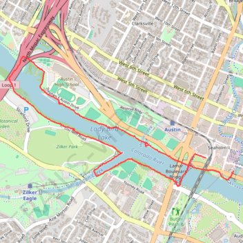
Western portion of the Ann & Roy Butler Trail in Austin, including the Pfluger Bridge
- Distance: 3.6 mi
- Elevation gain: 131 ft
- Maximum elevation: 479 ft
- Elevation loss: 144 ft
- Minimum elevation: 427 ft
- Moving time: 1 h 9 m
- Moving speed: 3.1 mph
- Maximum speed: 6.6 mph
- Total time: 1 h 20 m
- Global speed: 2.7 mph
Interactive trail map
Make a donation
Gear up for your next adventure:
As an Amazon Associate, this site earns from qualifying purchases at no extra cost to you.
Trail profile
- Distance: 3.6 mi
- Elevation gain: 131 ft
- Maximum elevation: 479 ft
- Elevation loss: 144 ft
- Minimum elevation: 427 ft
- Moving time: 1 h 9 m
- Moving speed: 3.1 mph
- Maximum speed: 6.6 mph
- Total time: 1 h 20 m
- Global speed: 2.7 mph
Make a donation
Gear up for your next adventure:
As an Amazon Associate, this site earns from qualifying purchases at no extra cost to you.
About this trail
Name: Western portion of the Ann & Roy Butler Trail in Austin, including the Pfluger Bridge trail, distance, elevation, map, profile, GPS track
Start: Shoal Creek Trail, Seaholm, Austin, Travis County, Texas, 78701, United States (30.26569 -97.75125)
End: Electric Drive, Seaholm, Austin, Travis County, Texas, 78701, United States (30.26678 -97.75389)
Coordinates: 30.26447 -97.77232 30.27498 -97.75125
Topography: Austin topographic map, elevation, terrain
Make a donation
Gear up for your next adventure:
As an Amazon Associate, this site earns from qualifying purchases at no extra cost to you.
Other hiking, mountain biking, running and outdoor activity trails
Click on a trail to view its statistics, map and profile.
Ann & Roy Butler Hike and Bike Trail in Austin
United States > Texas > Travis County > Austin
The Ann and Roy Butler Trail is a fantastic escape right in the heart of Austin, perfect for leisurely strolls or invigorating runs. With beautiful views of Lady Bird Lake, Colorado River and the Austin skyline, it’s a great spot to enjoy nature while still being close to the city buzz. Plus, there are…
Distance: 10.0 mi • Elevation gain: 387 ft • Maximum elevation: 479 ft
15_May_2026_1900
United States > Texas > Travis County > Austin
Distance: 2.8 mi • Elevation gain: 108 ft • Maximum elevation: 472 ft