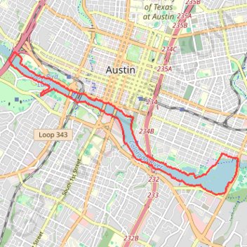
Ann & Roy Butler Hike and Bike Trail in Austin
The Ann and Roy Butler Trail is a fantastic escape right in the heart of Austin, perfect for leisurely strolls or invigorating runs. With beautiful views of Lady Bird Lake, Colorado River and the Austin skyline, it’s a great spot to enjoy nature while still being close to the city buzz. Plus, there are plenty of opportunities for snacks and drinks along the way, making it an ideal destination for both fitness enthusiasts and those looking to relax in a vibrant urban setting. #Hiking #Loop #River #City #Nature
- Distance: 10.0 mi
- Elevation gain: 387 ft
- Maximum elevation: 479 ft
- Elevation loss: 387 ft
- Minimum elevation: 423 ft
- Moving time: 3 h 3 m
- Moving speed: 3.3 mph
- Maximum speed: 6.7 mph
- Total time: 3 h 3 m
- Global speed: 3.3 mph
Interactive trail map
Trail profile
- Distance: 10.0 mi
- Elevation gain: 387 ft
- Maximum elevation: 479 ft
- Elevation loss: 387 ft
- Minimum elevation: 423 ft
- Moving time: 3 h 3 m
- Moving speed: 3.3 mph
- Maximum speed: 6.7 mph
- Total time: 3 h 3 m
- Global speed: 3.3 mph
About this trail
Name: Ann & Roy Butler Hike and Bike Trail in Austin trail, distance, elevation, map, profile, GPS track
Coordinates: 30.24336 -97.77231 30.27494 -97.71351
Topography: Austin topographic map, elevation, terrain
Other hiking, mountain biking, running and outdoor activity trails
Click on a trail to view its statistics, map and profile.
Northern shore of Butler Trail in Austin
United States > Texas > Travis County > Austin
Distance: 2.1 mi • Elevation gain: 92 ft • Maximum elevation: 479 ft
Butler Trail south shore boardwalk and Wishbone Bridge
United States > Texas > Travis County > Austin
Distance: 7.1 mi • Elevation gain: 285 ft • Maximum elevation: 489 ft
Central portion of the Ann & Roy Butler Trail including the Pfluger Bridge and South 1st Street Bridge
United States > Texas > Travis County > Austin
Distance: 1.9 mi • Elevation gain: 105 ft • Maximum elevation: 472 ft
Ann & Roy Butler Trail between I-35 and Wishbone Bridge
United States > Texas > Travis County > Austin
Distance: 3.8 mi • Elevation gain: 72 ft • Maximum elevation: 459 ft
Western portion of the Ann & Roy Butler Trail including the Pfluger Bridge
United States > Texas > Travis County > Austin
Distance: 3.7 mi • Elevation gain: 171 ft • Maximum elevation: 479 ft
Bike ride, fresh trail to Manor
United States > Texas > Travis County > Austin
Crowdstruck
Distance: 37.4 mi • Elevation gain: 1,299 ft • Maximum elevation: 679 ft