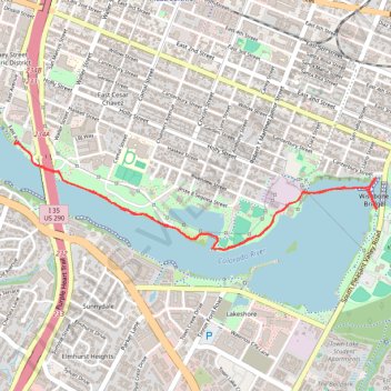
Ann & Roy Butler Trail between I-35 and Wishbone Bridge
- Distance: 3.8 mi
- Elevation gain: 72 ft
- Maximum elevation: 459 ft
- Elevation loss: 72 ft
- Minimum elevation: 433 ft
- Moving time: 1 h 11 m
- Moving speed: 3.2 mph
- Maximum speed: 13.6 mph
- Total time: 1 h 18 m
- Global speed: 2.9 mph
Interactive trail map
Trail profile
- Distance: 3.8 mi
- Elevation gain: 72 ft
- Maximum elevation: 459 ft
- Elevation loss: 72 ft
- Minimum elevation: 433 ft
- Moving time: 1 h 11 m
- Moving speed: 3.2 mph
- Maximum speed: 13.6 mph
- Total time: 1 h 18 m
- Global speed: 2.9 mph
About this trail
Name: Ann & Roy Butler Trail between I-35 and Wishbone Bridge trail, distance, elevation, map, profile, GPS track
Coordinates: 30.24708 -97.73833 30.25339 -97.71394
Topography: Austin topographic map, elevation, terrain
Other hiking, mountain biking, running and outdoor activity trails
Click on a trail to view its statistics, map and profile.
Ann & Roy Butler Hike and Bike Trail in Austin
United States > Texas > Travis County > Austin
The Ann and Roy Butler Trail is a fantastic escape right in the heart of Austin, perfect for leisurely strolls or invigorating runs. With beautiful views of Lady Bird Lake, Colorado River and the Austin skyline, it’s a great spot to enjoy nature while still being close to the city buzz. Plus, there are…
Distance: 10.0 mi • Elevation gain: 387 ft • Maximum elevation: 479 ft
Butler Trail south shore boardwalk and Wishbone Bridge
United States > Texas > Travis County > Austin
Distance: 7.1 mi • Elevation gain: 285 ft • Maximum elevation: 489 ft