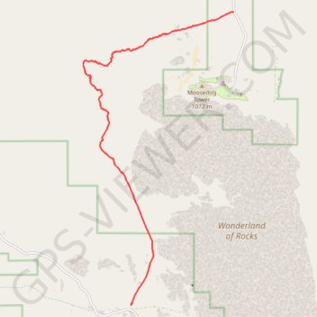
Import a GPX file

Boy Scout Trail

Hike on Boy Scout Trail through the Joshua Tree National Park. #Hiking #Nature #Desert #Rocks #Park

  • Distance: 8.0 mi
  • Elevation gain: 302 ft
  • Maximum elevation: 4,193 ft
  • Elevation loss: 1,483 ft
  • Minimum elevation: 2,854 ft

Interactive trail map

Trail profile

  • Distance: 8.0 mi
  • Elevation gain: 302 ft
  • Maximum elevation: 4,193 ft
  • Elevation loss: 1,483 ft
  • Minimum elevation: 2,854 ft

About this trail

Other hiking, mountain biking, running and outdoor activity trails

Click on a trail to view its statistics, map and profile.

California Riding and Hiking Trail (CRHT)

United States > California > San Bernardino County

Hike on the California Riding and Hiking Trail (CRHT) through the Joshua Tree National Park. #Hiking #Nature #Desert #Park #Mountain #CRHT

Distance: 36.4 mi • Elevation gain: 3,094 ft • Maximum elevation: 5,177 ft

Willow Hole

United States > California > San Bernardino County

Hike to Willow Hole by the Boy Scout Trail and the Willow Hole Trail via the Mustang Ranch, the Bear Island and the Wonderland of Rocks in the Joshua Tree National Park. #Hiking #Nature #Rocks #Desert #Park

Distance: 3.5 mi • Elevation gain: 200 ft • Maximum elevation: 4,167 ft

Boy Scout Trail

United States > California > San Bernardino County

Distance: 8.3 mi • Elevation gain: 1,463 ft • Maximum elevation: 4,193 ft

Gear up for your next adventure:

🎒Gear Packing Cubes - Organize your backpack efficiently
🥩Freeze-Dried Meals - Nutritious and lightweight food for remote expeditions
🚁Photography Drones - Capture stunning aerial views of landforms and topography
📱Solar Portable Charger - Solar power bank for charging devices off‑grid
☀️Outdoor Sunscreen - High protection sunscreen for outdoor activities

As an Amazon Associate, this site earns from qualifying purchases at no extra cost to you.