Anthony's Nose in Hudson Highlands State Park
The hike to Anthony's Nose offers an excellent balance of moderate difficulty and breathtaking views. As you ascend, the trail winds through rocky paths, with occasional steeper sections, ultimately revealing spectacular overlooks of the Hudson River, Bear Mountain Bridge, and the surrounding hills. Along the way, you'll pass several scenic viewpoints that make this hike worthwhile, including a prominent stop with panoramic views of Bear Mountain and the Perkins Memorial Tower. Though popular, the trail is accessible year-round, and during off-peak seasons, such as winter, you may enjoy a quieter experience. #Hiking #Overlook #Forest #Nature #River
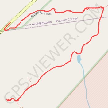
- Distance: 2.1 mi
- Elevation gain: 686 ft
- Maximum elevation: 869 ft
- Elevation loss: 689 ft
- Minimum elevation: 240 ft
- Moving time: 1 h 14 m
- Moving speed: 1.7 mph
- Maximum speed: 21.8 mph
- Total time: 1 h 54 m
- Global speed: 1.1 mph
Interactive trail map
Trail profile
- Distance: 2.1 mi
- Elevation gain: 686 ft
- Maximum elevation: 869 ft
- Elevation loss: 689 ft
- Minimum elevation: 240 ft
- Moving time: 1 h 14 m
- Moving speed: 1.7 mph
- Maximum speed: 21.8 mph
- Total time: 1 h 54 m
- Global speed: 1.1 mph
About this trail
Name: Anthony's Nose in Hudson Highlands State Park trail, distance, elevation, map, profile, GPS track
Coordinates: 41.31871 -73.97596 41.32378 -73.96877
Topography: Putnam County topographic map, elevation, terrain
Other hiking, mountain biking, running and outdoor activity trails
Click on a trail to view its statistics, map and profile.