Iceberg Lake from Fishercap Lake via Ptarmigan Trail, Ptarmigan Falls and Iceberg Lake Trail in Glacier National Park
The hike to Iceberg Lake in Glacier National Park offers a stunning journey through alpine terrain. Starting in the Many Glacier area, the trail winds through open meadows with wildflowers, forested paths, and striking vistas of rugged peaks. Key highlights include Ptarmigan Falls and the serene Iceberg Lake itself, which remains partially frozen even in summer, reflecting the towering cliffs surrounding it. The route is known for its gradual ascent and accessibility, making it a favorite for both novice and experienced hikers. #Hiking #Mountain #Forest #Nature #Lake #Glacier #Waterfall
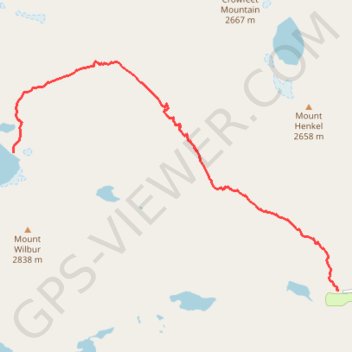
- Distance: 9.8 mi
- Elevation gain: 1,952 ft
- Maximum elevation: 6,148 ft
- Elevation loss: 1,919 ft
- Minimum elevation: 4,934 ft
Interactive trail map
Trail profile
- Distance: 9.8 mi
- Elevation gain: 1,952 ft
- Maximum elevation: 6,148 ft
- Elevation loss: 1,919 ft
- Minimum elevation: 4,934 ft
About this trail
Name: Iceberg Lake from Fishercap Lake via Ptarmigan Trail, Ptarmigan Falls and Iceberg Lake Trail in Glacier National Park trail, distance, elevation, map, profile, GPS track
Start: Many Glacier Road, Glacier County, Montana, United States (48.79760 -113.67745)
End: Ptarmigan Cutoff, Glacier County, Montana, United States (48.79974 -113.67929)
Coordinates: 48.79760 -113.74211 48.82752 -113.67745
Topography: Glacier County topographic map, elevation, terrain
Other hiking, mountain biking, running and outdoor activity trails
Click on a trail to view its statistics, map and profile.
Iceberg Lake from Swiftcurrent Lake via Ptarmigan Falls in Glacier National Park
United States > Montana > Glacier County
The hike to Iceberg Lake offers stunning scenery and an unforgettable experience. After a steep early ascent, the trail evens out, revealing breathtaking views of towering peaks like Mt. Wilbur and Swiftcurrent Mountain. You'll pass through forests, meadows, and valleys filled with wildflowers and wildlife…
Distance: 11.6 mi • Elevation gain: 1,896 ft • Maximum elevation: 6,148 ft
Iceberg Lake via Ptarmigan Trail in Glacier National Park
United States > Montana > Glacier County
The hike to Iceberg Lake via the Ptarmigan Trail in Glacier National Park offers breathtaking views of Mount Grinnell, Swiftcurrent Mountain, and Mount Wilbur. Along the trail, hikers traverse alpine meadows adorned with vibrant wildflowers and may encounter wildlife such as grizzly bears and moose. The…
Distance: 12.3 mi • Elevation gain: 1,959 ft • Maximum elevation: 6,152 ft