Make a donation
Gear up for your next adventure:
As an Amazon Associate, this site earns from qualifying purchases at no extra cost to you.
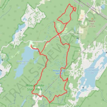
Swampy Wawayanda
- Distance: 16.0 mi
- Elevation gain: 1,230 ft
- Maximum elevation: 1,309 ft
- Elevation loss: 1,230 ft
- Minimum elevation: 1,063 ft
- Moving time: 2 h 39 m
- Moving speed: 6.0 mph
- Maximum speed: 19.9 mph
- Total time: 3 h 14 m
- Global speed: 4.9 mph
Interactive trail map
Make a donation
Gear up for your next adventure:
As an Amazon Associate, this site earns from qualifying purchases at no extra cost to you.
Trail profile
- Distance: 16.0 mi
- Elevation gain: 1,230 ft
- Maximum elevation: 1,309 ft
- Elevation loss: 1,230 ft
- Minimum elevation: 1,063 ft
- Moving time: 2 h 39 m
- Moving speed: 6.0 mph
- Maximum speed: 19.9 mph
- Total time: 3 h 14 m
- Global speed: 4.9 mph
Make a donation
Gear up for your next adventure:
As an Amazon Associate, this site earns from qualifying purchases at no extra cost to you.
About this trail
Name: Swampy Wawayanda trail, distance, elevation, map, profile, GPS track
Coordinates: 41.15686 -74.42869 41.21389 -74.39420
Topography: Sussex County topographic map, elevation, terrain
Make a donation
Gear up for your next adventure:
As an Amazon Associate, this site earns from qualifying purchases at no extra cost to you.
Other hiking, mountain biking, running and outdoor activity trails
Click on a trail to view its statistics, map and profile.
Pinwheel Vista via Appalachian Trail
United States > New Jersey > Sussex County > Vernon Township
Distance: 8.1 mi • Elevation gain: 1,358 ft • Maximum elevation: 1,339 ft
Nature Jim Tribute Ride
United States > New Jersey > Passaic County > West Milford > Moe
Wawayanda State Park
Distance: 12.3 mi • Elevation gain: 830 ft • Maximum elevation: 1,417 ft