Nature Jim Tribute Ride
Wawayanda State Park
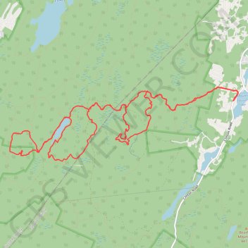
- Distance: 12.3 mi
- Elevation gain: 830 ft
- Maximum elevation: 1,417 ft
- Elevation loss: 830 ft
- Minimum elevation: 1,115 ft
- Moving time: 2 h 21 m
- Moving speed: 5.2 mph
- Maximum speed: 19.0 mph
- Total time: 3 h 29 m
- Global speed: 3.5 mph
Interactive trail map
Trail profile
- Distance: 12.3 mi
- Elevation gain: 830 ft
- Maximum elevation: 1,417 ft
- Elevation loss: 830 ft
- Minimum elevation: 1,115 ft
- Moving time: 2 h 21 m
- Moving speed: 5.2 mph
- Maximum speed: 19.0 mph
- Total time: 3 h 29 m
- Global speed: 3.5 mph
About this trail
Name: Nature Jim Tribute Ride trail, distance, elevation, map, profile, GPS track
Start: Atco Court, Moe, West Milford, Passaic County, New Jersey, 07421, United States (41.16200 -74.39431)
Coordinates: 41.15145 -74.44655 41.16453 -74.39305
Topography: Passaic County topographic map, elevation, terrain
Other hiking, mountain biking, running and outdoor activity trails
Click on a trail to view its statistics, map and profile.
Swampy Wawayanda
United States > New Jersey > Sussex County > Vernon Township > Wawayanda
Distance: 16.0 mi • Elevation gain: 1,230 ft • Maximum elevation: 1,309 ft