Make a donation
Gear up for your next adventure:
As an Amazon Associate, this site earns from qualifying purchases at no extra cost to you.
Mount Olympus Trail
Embarking on the Mount Olympus Trail in Utah offers hikers a challenging ascent through diverse terrains, including dense forests and rocky outcrops. As you progress, the trail provides sweeping vistas of the Salt Lake Valley and the expansive Wasatch Mountain Range. Upon reaching the summit, you're rewarded with panoramic views that stretch from Lone Peak to Francis Peak, showcasing the region's natural splendor. #Hiking #Mountain #Forest #Nature
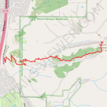
- Distance: 6.9 mi
- Elevation gain: 4,085 ft
- Maximum elevation: 8,934 ft
- Elevation loss: 4,081 ft
- Minimum elevation: 4,846 ft
- Moving time: 2 h 48 m
- Moving speed: 2.5 mph
- Maximum speed: 9.9 mph
- Total time: 3 h 19 m
- Global speed: 2.1 mph
Interactive trail map
Make a donation
Gear up for your next adventure:
As an Amazon Associate, this site earns from qualifying purchases at no extra cost to you.
Trail profile
- Distance: 6.9 mi
- Elevation gain: 4,085 ft
- Maximum elevation: 8,934 ft
- Elevation loss: 4,081 ft
- Minimum elevation: 4,846 ft
- Moving time: 2 h 48 m
- Moving speed: 2.5 mph
- Maximum speed: 9.9 mph
- Total time: 3 h 19 m
- Global speed: 2.1 mph
Make a donation
Gear up for your next adventure:
As an Amazon Associate, this site earns from qualifying purchases at no extra cost to you.
About this trail
Name: Mount Olympus Trail trail, distance, elevation, map, profile, GPS track
End: Mount Olympus Trail, Salt Lake County, Utah, 84121, United States (40.65253 -111.80621)
Coordinates: 40.65053 -111.80624 40.65682 -111.77090
Topography: Salt Lake County topographic map, elevation, terrain
Make a donation
Gear up for your next adventure:
As an Amazon Associate, this site earns from qualifying purchases at no extra cost to you.
Other hiking, mountain biking, running and outdoor activity trails
Click on a trail to view its statistics, map and profile.
Mount Olympus Trail
United States > Utah > Salt Lake County
The Mount Olympus Trail is a challenging and rewarding hike near Salt Lake City, offering spectacular views of the surrounding valley, including glimpses of the Wasatch Mountains. As you ascend, the trail takes you through a variety of terrain, with steep switchbacks and rock steps leading to a thrilling final…
Distance: 6.6 mi • Elevation gain: 4,062 ft • Maximum elevation: 8,930 ft