Make a donation
Gear up for your next adventure:
As an Amazon Associate, this site earns from qualifying purchases at no extra cost to you.
Mount Olympus Trail
The Mount Olympus Trail is a challenging and rewarding hike near Salt Lake City, offering spectacular views of the surrounding valley, including glimpses of the Wasatch Mountains. As you ascend, the trail takes you through a variety of terrain, with steep switchbacks and rock steps leading to a thrilling final scramble to the summit. Hikers are treated to panoramic vistas, especially from the saddle, where distant peaks like Broads Fork Twin Peaks and Lone Peak come into view. #Hiking #Mountain #Forest #Nature #Overlook
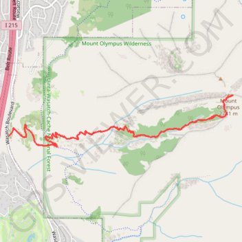
- Distance: 6.6 mi
- Elevation gain: 4,062 ft
- Maximum elevation: 8,930 ft
- Elevation loss: 4,062 ft
- Minimum elevation: 4,865 ft
Interactive trail map
Make a donation
Gear up for your next adventure:
As an Amazon Associate, this site earns from qualifying purchases at no extra cost to you.
Trail profile
- Distance: 6.6 mi
- Elevation gain: 4,062 ft
- Maximum elevation: 8,930 ft
- Elevation loss: 4,062 ft
- Minimum elevation: 4,865 ft
Make a donation
Gear up for your next adventure:
As an Amazon Associate, this site earns from qualifying purchases at no extra cost to you.
About this trail
Name: Mount Olympus Trail trail, distance, elevation, map, profile, GPS track
Start: Mount Olympus Trail, Salt Lake County, Utah, 84121, United States (40.65181 -111.80616)
End: Mount Olympus Trail, Salt Lake County, Utah, 84121, United States (40.65180 -111.80617)
Coordinates: 40.65051 -111.80617 40.65672 -111.77033
Topography: Salt Lake County topographic map, elevation, terrain
Make a donation
Gear up for your next adventure:
As an Amazon Associate, this site earns from qualifying purchases at no extra cost to you.
Other hiking, mountain biking, running and outdoor activity trails
Click on a trail to view its statistics, map and profile.
Mount Olympus Trail
United States > Utah > Salt Lake County
Embarking on the Mount Olympus Trail in Utah offers hikers a challenging ascent through diverse terrains, including dense forests and rocky outcrops. As you progress, the trail provides sweeping vistas of the Salt Lake Valley and the expansive Wasatch Mountain Range. Upon reaching the summit, you're rewarded…
Distance: 6.9 mi • Elevation gain: 4,085 ft • Maximum elevation: 8,934 ft