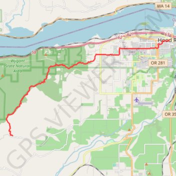
Post Canyon from Binns Hill to Hood River
Mountain Bike in Post Canyon from Binns Hill Staging Area to Hood River via Blade Runner and Mitchel Ridge trails. Columbia River Gorge National Scenic Area. #MTB #Canyon #Mountain #Forest #River #Nature
- Distance: 10.3 mi
- Elevation gain: 669 ft
- Maximum elevation: 2,644 ft
- Elevation loss: 2,890 ft
- Minimum elevation: 180 ft
Interactive trail map
Trail profile
- Distance: 10.3 mi
- Elevation gain: 669 ft
- Maximum elevation: 2,644 ft
- Elevation loss: 2,890 ft
- Minimum elevation: 180 ft
About this trail
Name: Post Canyon from Binns Hill to Hood River trail, distance, elevation, map, profile, GPS track
Start: 160 Trail, Hood River County, Oregon, United States (45.65428 -121.64115)
End: Oak Street, Hood River, Hood River County, Oregon, 97031, United States (45.70861 -121.51484)
Coordinates: 45.65428 -121.64605 45.70861 -121.51424
Topography: Hood River County topographic map, elevation, terrain
Other hiking, mountain biking, running and outdoor activity trails
Click on a trail to view its statistics, map and profile.
Northern part of the Pacific Crest Trail (PCT)
United States > Oregon > Klamath County
Hike on the Pacific Crest National Scenic Trail from Crater Lake to Canada Border through Oregon and Washington along the Sierra Nevada and Cascade mountain ranges. #Hiking #Mountain #SierraNevada #Cascade #Nature #Forest #Park #PCT
Distance: 744.6 mi • Elevation gain: 145,367 ft • Maximum elevation: 7,569 ft
Post Canyon
United States > Oregon > Hood River County
#MTB
Distance: 13.9 mi • Elevation gain: 2,579 ft • Maximum elevation: 2,444 ft
MTB ride in Hood River
United States > Oregon > Hood River County
Distance: 11.1 mi • Elevation gain: 2,087 ft • Maximum elevation: 2,034 ft