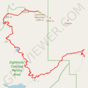
Cashmere Mountain via Little Eightmile Lake, Eightmile-Trout Creek Trail, Lake Caroline and Windy Pass
The hike to Cashmere Mountain is a spectacular journey through the heart of the Alpine Lakes Wilderness, offering a diverse range of views. Starting at the Eightmile Lake Trailhead, the route leads you past scenic lakes like Little Eightmile Lake and Lake Caroline, each with pristine alpine waters framed by rugged peaks. As you continue, the trail ascends to Windy Pass, providing expansive vistas of the surrounding wilderness, including impressive views of Cashmere Mountain itself. The landscape is a mix of lush meadows, rocky talus slopes, and burned areas, creating a stark contrast of textures and colors along the way. This challenging route is known for its strenuous elevation gain, especially in the upper sections, but the stunning panoramas make it well worth the effort. #Hiking #Mountain #Forest #Lake #Nature
- Distance: 9.5 mi
- Elevation gain: 5,502 ft
- Maximum elevation: 8,235 ft
- Elevation loss: 535 ft
- Minimum elevation: 3,264 ft
Interactive trail map
Trail profile
- Distance: 9.5 mi
- Elevation gain: 5,502 ft
- Maximum elevation: 8,235 ft
- Elevation loss: 535 ft
- Minimum elevation: 3,264 ft
About this trail
Name: Cashmere Mountain via Little Eightmile Lake, Eightmile-Trout Creek Trail, Lake Caroline and Windy Pass trail, distance, elevation, map, profile, GPS track
Start: Eight Mile Road, Chelan County, Washington, United States (47.53586 -120.81313)
End: Chelan County, Washington, United States (47.55930 -120.84837)
Coordinates: 47.52485 -120.87492 47.55977 -120.81313
Topography: Chelan County topographic map, elevation, terrain
Other hiking, mountain biking, running and outdoor activity trails
Click on a trail to view its statistics, map and profile.
The Enchantments
United States > Washington > Chelan County
From the Stuart Lake Trail, the route enters the Alpine Lakes Wilderness through forest, creek crossings, and gradually rougher alpine terrain before reaching Colchuck Lake, a striking first landmark set below Colchuck Peak and Dragontail Peak, with Aasgard Pass rising steeply above the far shore as the…
Distance: 18.2 mi • Elevation gain: 4,928 ft • Maximum elevation: 7,818 ft
Colchuck Lake via Stuart Lake Trail and Colchuck Lake Trail in Alpine Lakes Wilderness
United States > Washington > Chelan County
The Colchuck Lake hike offers a challenging yet incredibly rewarding adventure through Washington's rugged Alpine Lakes Wilderness. As you ascend, the trail meanders through dense forests and rocky terrain, with spectacular views opening up toward Dragontail Peak and the Colchuck Glacier. The final…
Distance: 8.0 mi • Elevation gain: 2,326 ft • Maximum elevation: 5,587 ft
Lake Stuart via Stuart Lake Trail in Alpine Lakes Wilderness
United States > Washington > Chelan County
The hike to Lake Stuart in the Alpine Lakes Wilderness offers a serene journey through lush forests, alongside Mountaineer Creek, and past impressive glacial boulders. The route gradually transitions from shaded woodland paths to expansive meadows that unveil stunning views of Mount Stuart towering above the…
Distance: 4.1 mi • Elevation gain: 1,765 ft • Maximum elevation: 5,118 ft
Colchuck Lake Trail in Okanogan-Wenatchee National Forest
United States > Washington > Chelan County
The Colchuck Lake Trail is a delightful hike that leads you to one of the most stunning alpine lakes in Washington. Starting off with a gentle climb through lush forests, the trail gradually transforms into rocky terrain, offering breathtaking views of the towering Dragontail and Colchuck Peaks as you near the…
Distance: 9.6 mi • Elevation gain: 2,375 ft • Maximum elevation: 5,636 ft
Northern part of the Pacific Crest Trail (PCT)
United States > Oregon > Klamath County
Hike on the Pacific Crest National Scenic Trail from Crater Lake to Canada Border through Oregon and Washington along the Sierra Nevada and Cascade mountain ranges. #Hiking #Mountain #SierraNevada #Cascade #Nature #Forest #Park #PCT
Distance: 744.6 mi • Elevation gain: 145,367 ft • Maximum elevation: 7,569 ft
Enchantments traverse
United States > Washington > Chelan County
Distance: 20.3 mi • Elevation gain: 5,115 ft • Maximum elevation: 7,818 ft
Enchantmentpeak on GPSies.com
United States > Washington > Chelan County
Distance: 7.6 mi • Elevation gain: 5,830 ft • Maximum elevation: 8,438 ft