Alpy Julijskie - Aljazev Dom - M. Triglav, Triglav
- Distance: 10.3 mi
- Elevation gain: 8,064 ft
- Maximum elevation: 9,281 ft
- Elevation loss: 8,064 ft
- Minimum elevation: 3,241 ft
- Moving time: 8 h 43 m
- Moving speed: 1.2 mph
- Maximum speed: 3.2 mph
- Total time: 12 h 41 m
- Global speed: 0.8 mph
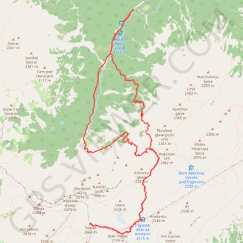
Interactive trail map
Trail profile
- Distance: 10.3 mi
- Elevation gain: 8,064 ft
- Maximum elevation: 9,281 ft
- Elevation loss: 8,064 ft
- Minimum elevation: 3,241 ft
- Moving time: 8 h 43 m
- Moving speed: 1.2 mph
- Maximum speed: 3.2 mph
- Total time: 12 h 41 m
- Global speed: 0.8 mph
About this trail
Name: Alpy Julijskie - Aljazev Dom - M. Triglav, Triglav trail, distance, elevation, map, profile, GPS track
Start: Triglavska cesta, Kranjska Gora, Slovenia (46.41274 13.84674)
End: Triglavska cesta, Kranjska Gora, Slovenia (46.41266 13.84663)
Coordinates: 46.37662 13.83507 46.41283 13.85275
Other hiking, mountain biking, running and outdoor activity trails
Click on a trail to view its statistics, map and profile.
Bled - Bohinj
File with points/tracks from Locus Map/4.11.1
Distance: 22.7 mi • Elevation gain: 2,428 ft • Maximum elevation: 1,936 ft
Triglav (Konjšica)
Distance: 16.6 mi • Elevation gain: 6,965 ft • Maximum elevation: 9,291 ft
Триглав
Distance: 4.0 mi • Elevation gain: 6,404 ft • Maximum elevation: 9,295 ft
TRIGLAV por la ferrata Plemanice
Slovenia > Bovec > Pri Cerkvi
Distance: 18.4 mi • Elevation gain: 11,122 ft • Maximum elevation: 9,295 ft