Move
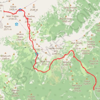
- Distance: 14.5 mi
- Elevation gain: 6,568 ft
- Maximum elevation: 9,288 ft
- Elevation loss: 6,552 ft
- Minimum elevation: 4,298 ft
- Moving time: 9 h 24 m
- Moving speed: 1.5 mph
- Maximum speed: 2.9 mph
- Total time: 12 h 55 m
- Global speed: 1.1 mph
Interactive trail map
Trail profile
- Distance: 14.5 mi
- Elevation gain: 6,568 ft
- Maximum elevation: 9,288 ft
- Elevation loss: 6,552 ft
- Minimum elevation: 4,298 ft
- Moving time: 9 h 24 m
- Moving speed: 1.5 mph
- Maximum speed: 2.9 mph
- Total time: 12 h 55 m
- Global speed: 1.1 mph
About this trail
Name: Move trail, distance, elevation, map, profile, GPS track
Start: Bohinj, 4267, Slovenia (46.33688 13.90464)
End: Bohinj, 4267, Slovenia (46.33714 13.90474)
Coordinates: 46.33688 13.83642 46.37899 13.90640
Other hiking, mountain biking, running and outdoor activity trails
Click on a trail to view its statistics, map and profile.
Bled - Bohinj
File with points/tracks from Locus Map/4.11.1
Distance: 22.7 mi • Elevation gain: 2,428 ft • Maximum elevation: 1,936 ft
Triglav (Konjšica)
Distance: 16.6 mi • Elevation gain: 6,965 ft • Maximum elevation: 9,291 ft
Триглав
Distance: 4.0 mi • Elevation gain: 6,404 ft • Maximum elevation: 9,295 ft
JULIANA BIKE - stage 1: Bohinjska Bistrica - Goreljek
Along the Sava Bohinjka River to Lake Bohinj and upwards to Pokljuka
Distance: 19.7 mi • Elevation gain: 4,042 ft • Maximum elevation: 4,541 ft
TRIGLAV por la ferrata Plemanice
Slovenia > Bovec > Pri Cerkvi
Distance: 18.4 mi • Elevation gain: 11,122 ft • Maximum elevation: 9,295 ft
Alpy Julijskie - Aljazev Dom - M. Triglav, Triglav
Distance: 10.3 mi • Elevation gain: 8,064 ft • Maximum elevation: 9,281 ft