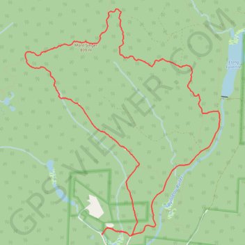
Mount Singer
Montagnes-Vertes Nature Reserve. #Hiking #Snowshoeing #Loop #MontagnesVertes #Nature
- Distance: 8.8 mi
- Elevation gain: 1,972 ft
- Maximum elevation: 2,625 ft
- Elevation loss: 1,972 ft
- Minimum elevation: 932 ft
Interactive trail map
Trail profile
- Distance: 8.8 mi
- Elevation gain: 1,972 ft
- Maximum elevation: 2,625 ft
- Elevation loss: 1,972 ft
- Minimum elevation: 932 ft
About this trail
Name: Mount Singer trail, distance, elevation, map, profile, GPS track
Start: MontagnesVertes-Decouvertes, Potton, Memphrémagog, Quebec, Canada (45.10438 -72.45273)
End: MontagnesVertes-Decouvertes, Potton, Memphrémagog, Quebec, Canada (45.10438 -72.45273)
Coordinates: 45.10412 -72.46921 45.13825 -72.42766
Other hiking, mountain biking, running and outdoor activity trails
Click on a trail to view its statistics, map and profile.