Make a donation
Gear up for your next adventure:
As an Amazon Associate, this site earns from qualifying purchases at no extra cost to you.
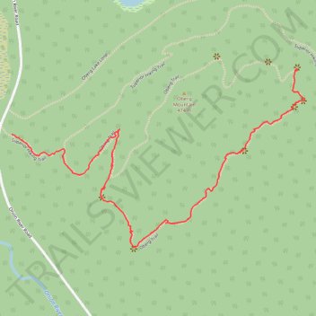
Oberg Trail
- Distance: 1.3 mi
- Elevation gain: 377 ft
- Maximum elevation: 1,453 ft
- Elevation loss: 272 ft
- Minimum elevation: 1,240 ft
- Moving time: 40 m 56 s
- Moving speed: 2.0 mph
- Maximum speed: 4.3 mph
- Total time: 1 h 3 m
- Global speed: 1.3 mph
Interactive trail map
Make a donation
Gear up for your next adventure:
As an Amazon Associate, this site earns from qualifying purchases at no extra cost to you.
Trail profile
- Distance: 1.3 mi
- Elevation gain: 377 ft
- Maximum elevation: 1,453 ft
- Elevation loss: 272 ft
- Minimum elevation: 1,240 ft
- Moving time: 40 m 56 s
- Moving speed: 2.0 mph
- Maximum speed: 4.3 mph
- Total time: 1 h 3 m
- Global speed: 1.3 mph
Make a donation
Gear up for your next adventure:
As an Amazon Associate, this site earns from qualifying purchases at no extra cost to you.
About this trail
Name: Oberg Trail trail, distance, elevation, map, profile, GPS track
Start: Superior Hiking Trail, Tofte Township, Cook County, Minnesota, United States (47.62737 -90.78300)
End: Oberg Trail, Tofte Township, Cook County, Minnesota, United States (47.62928 -90.77065)
Coordinates: 47.62407 -90.78300 47.62928 -90.77031
Topography: Cook County topographic map, elevation, terrain
Make a donation
Gear up for your next adventure:
As an Amazon Associate, this site earns from qualifying purchases at no extra cost to you.
Other hiking, mountain biking, running and outdoor activity trails
Click on a trail to view its statistics, map and profile.
Oberg Mountain Loop Trail in Superior National Forest
United States > Minnesota > Cook County
The Oberg Mountain Loop Trail is a rewarding hike, offering breathtaking views of the surrounding forest, lakes, and distant mountains. Along the trail, you’ll experience several scenic overlooks that provide sweeping vistas of the blue expanse of Lake Superior, the rugged Sawtooth Mountains, and the dense,…
Distance: 2.3 mi • Elevation gain: 591 ft • Maximum elevation: 1,516 ft