Oberg Mountain Loop Trail in Superior National Forest
The Oberg Mountain Loop Trail is a rewarding hike, offering breathtaking views of the surrounding forest, lakes, and distant mountains. Along the trail, you’ll experience several scenic overlooks that provide sweeping vistas of the blue expanse of Lake Superior, the rugged Sawtooth Mountains, and the dense, lush forests that characterize the region. The path winds through a variety of terrains, including rocky ridges and forested areas, making it especially stunning during the fall when the foliage transforms into vibrant hues. #Hiking #Loop #Lake #Forest #Nature
- Distance: 2.3 mi
- Elevation gain: 591 ft
- Maximum elevation: 1,516 ft
- Elevation loss: 581 ft
- Minimum elevation: 1,224 ft
- Moving time: 50 m 34 s
- Moving speed: 2.7 mph
- Maximum speed: 4.4 mph
- Total time: 54 m 46 s
- Global speed: 2.5 mph
Interactive trail map
Trail profile
- Distance: 2.3 mi
- Elevation gain: 591 ft
- Maximum elevation: 1,516 ft
- Elevation loss: 581 ft
- Minimum elevation: 1,224 ft
- Moving time: 50 m 34 s
- Moving speed: 2.7 mph
- Maximum speed: 4.4 mph
- Total time: 54 m 46 s
- Global speed: 2.5 mph
About this trail
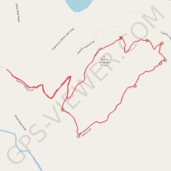
Name: Oberg Mountain Loop Trail in Superior National Forest trail, distance, elevation, map, profile, GPS track
Start: Superior Hiking Trail, Tofte Township, Cook County, Minnesota, United States (47.62782 -90.78383)
End: Superior Hiking Trail, Tofte Township, Cook County, Minnesota, United States (47.62755 -90.78337)
Coordinates: 47.62411 -90.78383 47.62971 -90.77041
Topography: Cook County topographic map, elevation, terrain
Other hiking, mountain biking, running and outdoor activity trails
Click on a trail to view its statistics, map and profile.
Oberg Trail
United States > Minnesota > Cook County
Distance: 1.3 mi • Elevation gain: 377 ft • Maximum elevation: 1,453 ft