Make a donation
Gear up for your next adventure:
As an Amazon Associate, this site earns from qualifying purchases at no extra cost to you.
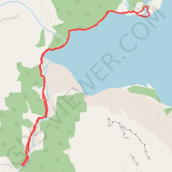
Bow Lake - Glacier Falls
- Distance: 4.2 mi
- Elevation gain: 407 ft
- Maximum elevation: 6,601 ft
- Elevation loss: 407 ft
- Minimum elevation: 6,358 ft
Interactive trail map
Make a donation
Gear up for your next adventure:
As an Amazon Associate, this site earns from qualifying purchases at no extra cost to you.
Trail profile
- Distance: 4.2 mi
- Elevation gain: 407 ft
- Maximum elevation: 6,601 ft
- Elevation loss: 407 ft
- Minimum elevation: 6,358 ft
Make a donation
Gear up for your next adventure:
As an Amazon Associate, this site earns from qualifying purchases at no extra cost to you.
About this trail
Name: Bow Lake - Glacier Falls trail, distance, elevation, map, profile, GPS track
Start: Bow Glacier Falls Trail, Improvement District No. 9, Alberta, Canada (51.67879 -116.46491)
End: Bow Glacier Falls Trail, Improvement District No. 9, Alberta, Canada (51.67878 -116.46502)
Coordinates: 51.66060 -116.48800 51.67879 -116.46432
Make a donation
Gear up for your next adventure:
As an Amazon Associate, this site earns from qualifying purchases at no extra cost to you.
Other hiking, mountain biking, running and outdoor activity trails
Click on a trail to view its statistics, map and profile.
Bow Lake - Glacier Falls
Canada > Alberta > Improvement District No. 9
Distance: 4.2 mi • Elevation gain: 407 ft • Maximum elevation: 6,601 ft
Make a donation
Gear up for your next adventure:
As an Amazon Associate, this site earns from qualifying purchases at no extra cost to you.