Bow Lake - Bow Hut - Wapta Icefield
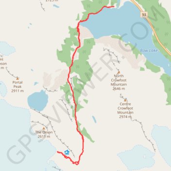
Interactive trail map
Trail profile
- Distance: 10.0 mi
- Elevation gain: 2,067 ft
- Maximum elevation: 8,084 ft
- Elevation loss: 2,064 ft
- Minimum elevation: 6,358 ft
About this trail
Name: Bow Lake - Bow Hut - Wapta Icefield trail, distance, elevation, map, profile, GPS track
Start: Bow Glacier Falls Trail, Improvement District No. 9, Alberta, Canada (51.67815 -116.46831)
End: Bow Glacier Falls Trail, Improvement District No. 9, Alberta, Canada (51.67822 -116.46701)
Coordinates: 51.63088 -116.49445 51.67830 -116.46699
Other hiking, mountain biking, running and outdoor activity trails
Click on a trail to view its statistics, map and profile.
Bow Lake - Glacier Falls
Canada > Alberta > Improvement District No. 9
Distance: 4.2 mi • Elevation gain: 407 ft • Maximum elevation: 6,601 ft
Bow Lake - Glacier Falls
Canada > Alberta > Improvement District No. 9
Distance: 4.2 mi • Elevation gain: 407 ft • Maximum elevation: 6,601 ft