Thank you for supporting this site ❤️
Make a donation
Make a donation
Gear up for your next adventure:
As an Amazon Associate, this site earns from qualifying purchases at no extra cost to you.
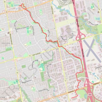
Beaver Greenway Trail
- Distance: 7.2 mi
- Elevation gain: 161 ft
- Maximum elevation: 741 ft
- Elevation loss: 190 ft
- Minimum elevation: 617 ft
- Moving time: 1 h 19 m
- Moving speed: 5.4 mph
- Maximum speed: 12.0 mph
- Total time: 1 h 20 m
- Global speed: 5.3 mph
Interactive trail map
Thank you for supporting this site ❤️
Make a donation
Make a donation
Gear up for your next adventure:
As an Amazon Associate, this site earns from qualifying purchases at no extra cost to you.
Trail profile
- Distance: 7.2 mi
- Elevation gain: 161 ft
- Maximum elevation: 741 ft
- Elevation loss: 190 ft
- Minimum elevation: 617 ft
- Moving time: 1 h 19 m
- Moving speed: 5.4 mph
- Maximum speed: 12.0 mph
- Total time: 1 h 20 m
- Global speed: 5.3 mph
Thank you for supporting this site ❤️
Make a donation
Make a donation
Gear up for your next adventure:
As an Amazon Associate, this site earns from qualifying purchases at no extra cost to you.
About this trail
Name: Beaver Greenway Trail trail, distance, elevation, map, profile, GPS track
Coordinates: 43.84235 -79.40873 43.87928 -79.37378
Thank you for supporting this site ❤️
Make a donation
Make a donation
Gear up for your next adventure:
As an Amazon Associate, this site earns from qualifying purchases at no extra cost to you.
Other hiking, mountain biking, running and outdoor activity trails
Click on a trail to view its statistics, map and profile.