Make a donation
Gear up for your next adventure:
As an Amazon Associate, this site earns from qualifying purchases at no extra cost to you.
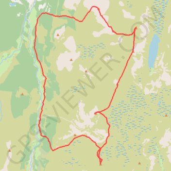
Munro hillwalk Sgor Gaoith Mullach Clach a' Bhlair
- Distance: 18.7 mi
- Elevation gain: 3,796 ft
- Maximum elevation: 3,635 ft
- Elevation loss: 3,799 ft
- Minimum elevation: 935 ft
- Moving time: 7 h 16 m
- Moving speed: 2.6 mph
- Maximum speed: 14.7 mph
- Total time: 8 h 2 m
- Global speed: 2.3 mph
Interactive trail map
Make a donation
Gear up for your next adventure:
As an Amazon Associate, this site earns from qualifying purchases at no extra cost to you.
Trail profile
- Distance: 18.7 mi
- Elevation gain: 3,796 ft
- Maximum elevation: 3,635 ft
- Elevation loss: 3,799 ft
- Minimum elevation: 935 ft
- Moving time: 7 h 16 m
- Moving speed: 2.6 mph
- Maximum speed: 14.7 mph
- Total time: 8 h 2 m
- Global speed: 2.3 mph
Make a donation
Gear up for your next adventure:
As an Amazon Associate, this site earns from qualifying purchases at no extra cost to you.
About this trail
Name: Munro hillwalk Sgor Gaoith Mullach Clach a' Bhlair trail, distance, elevation, map, profile, GPS track
Start: Achlean Road, Highland, Scotland, PH21 1NH, United Kingdom (57.08770 -3.89497)
End: Achlean Road, Highland, Scotland, PH21 1NH, United Kingdom (57.08782 -3.89497)
Coordinates: 57.01164 -3.90231 57.09121 -3.80788
Make a donation
Gear up for your next adventure:
As an Amazon Associate, this site earns from qualifying purchases at no extra cost to you.
Other hiking, mountain biking, running and outdoor activity trails
Click on a trail to view its statistics, map and profile.
Cairngorms hike
United Kingdom > Scotland > Highland > Aviemore
Distance: 50.2 mi • Elevation gain: 9,846 ft • Maximum elevation: 4,304 ft