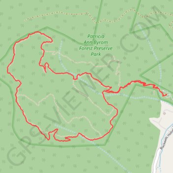
Patricia Ann Byrom Forrest Preserve Park
- Distance: 4.6 mi
- Elevation gain: 1,329 ft
- Maximum elevation: 2,257 ft
- Elevation loss: 1,332 ft
- Minimum elevation: 1,037 ft
- Moving time: 2 h 27 m
- Moving speed: 1.9 mph
- Maximum speed: 4.1 mph
- Total time: 2 h 29 m
- Global speed: 1.9 mph
Interactive trail map
Trail profile
- Distance: 4.6 mi
- Elevation gain: 1,329 ft
- Maximum elevation: 2,257 ft
- Elevation loss: 1,332 ft
- Minimum elevation: 1,037 ft
- Moving time: 2 h 27 m
- Moving speed: 1.9 mph
- Maximum speed: 4.1 mph
- Total time: 2 h 29 m
- Global speed: 1.9 mph
About this trail
Name: Patricia Ann Byrom Forrest Preserve Park trail, distance, elevation, map, profile, GPS track
Start: Great Mountains Trail, Albemarle County, Virginia, United States (38.22102 -78.64965)
End: Great Mountains Trail, Albemarle County, Virginia, United States (38.22088 -78.64995)
Coordinates: 38.21628 -78.67017 38.22737 -78.64951
Topography: Albemarle County topographic map, elevation, terrain
Other hiking, mountain biking, running and outdoor activity trails
Click on a trail to view its statistics, map and profile.
Patricia Ann Byrom Forest Preserve Park
United States > Virginia > Albemarle County
Distance: 2.0 mi • Elevation gain: 509 ft • Maximum elevation: 1,532 ft