Make a donation
Gear up for your next adventure:
As an Amazon Associate, this site earns from qualifying purchases at no extra cost to you.
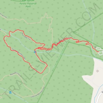
Patricia Ann Byrom Forest Preserve Park
- Distance: 2.0 mi
- Elevation gain: 509 ft
- Maximum elevation: 1,532 ft
- Elevation loss: 358 ft
- Minimum elevation: 1,043 ft
- Moving time: 58 m
- Moving speed: 2.0 mph
- Maximum speed: 4.3 mph
- Total time: 58 m
- Global speed: 2.0 mph
Interactive trail map
Make a donation
Gear up for your next adventure:
As an Amazon Associate, this site earns from qualifying purchases at no extra cost to you.
Trail profile
- Distance: 2.0 mi
- Elevation gain: 509 ft
- Maximum elevation: 1,532 ft
- Elevation loss: 358 ft
- Minimum elevation: 1,043 ft
- Moving time: 58 m
- Moving speed: 2.0 mph
- Maximum speed: 4.3 mph
- Total time: 58 m
- Global speed: 2.0 mph
Make a donation
Gear up for your next adventure:
As an Amazon Associate, this site earns from qualifying purchases at no extra cost to you.
About this trail
Name: Patricia Ann Byrom Forest Preserve Park trail, distance, elevation, map, profile, GPS track
Start: Great Mountains Trail, Albemarle County, Virginia, United States (38.22099 -78.64962)
End: Great Mountains Trail, Albemarle County, Virginia, United States (38.22228 -78.65361)
Coordinates: 38.21886 -78.66176 38.22324 -78.64962
Topography: Albemarle County topographic map, elevation, terrain
Make a donation
Gear up for your next adventure:
As an Amazon Associate, this site earns from qualifying purchases at no extra cost to you.
Other hiking, mountain biking, running and outdoor activity trails
Click on a trail to view its statistics, map and profile.
Patricia Ann Byrom Forrest Preserve Park
United States > Virginia > Albemarle County
Distance: 4.6 mi • Elevation gain: 1,329 ft • Maximum elevation: 2,257 ft