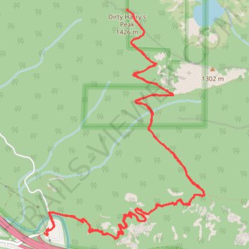
Dirty Harry's Peak Trail
- Distance: 8.7 mi
- Elevation gain: 3,596 ft
- Maximum elevation: 4,570 ft
- Elevation loss: 3,606 ft
- Minimum elevation: 1,312 ft
Interactive trail map
Trail profile
- Distance: 8.7 mi
- Elevation gain: 3,596 ft
- Maximum elevation: 4,570 ft
- Elevation loss: 3,606 ft
- Minimum elevation: 1,312 ft
About this trail
Name: Dirty Harry's Peak Trail trail, distance, elevation, map, profile, GPS track
End: Southeast Homestead Valley Road, King County, Washington, United States (47.43106 -121.63269)
Coordinates: 47.43051 -121.63269 47.45133 -121.61119
Topography: King County topographic map, elevation, terrain
Other hiking, mountain biking, running and outdoor activity trails
Click on a trail to view its statistics, map and profile.
Dirty Harry's Balcony in Middle Fork Snoqualmie Natural Resources Conservation Area
United States > Washington > King County
Dirty Harry's Balcony, nestled within the Middle Fork Snoqualmie Natural Resources Conservation Area, offers hikers a rewarding journey through dense forests adorned with towering conifers and lush undergrowth. As you ascend the Dirty Harry's Peak Trail, remnants of the area's logging history, such as old…
Distance: 4.5 mi • Elevation gain: 1,568 ft • Maximum elevation: 2,579 ft
Dirty Harry's Peak Trail in Middle Fork Snoqualmie Natural Resources Conservation Area
United States > Washington > King County
The Dirty Harry's Peak Trail offers a vigorous and rewarding hike through the Middle Fork Snoqualmie Natural Resources Conservation Area. The route begins by climbing steadily through dense forests, eventually breaking into rocky terrain with expansive views of the surrounding peaks and valleys. From the…
Distance: 8.0 mi • Elevation gain: 3,547 ft • Maximum elevation: 4,567 ft
Northern part of the Pacific Crest Trail (PCT)
United States > Oregon > Klamath County
Hike on the Pacific Crest National Scenic Trail from Crater Lake to Canada Border through Oregon and Washington along the Sierra Nevada and Cascade mountain ranges. #Hiking #Mountain #SierraNevada #Cascade #Nature #Forest #Park #PCT
Distance: 744.6 mi • Elevation gain: 145,367 ft • Maximum elevation: 7,569 ft