Make a donation
Gear up for your next adventure:
As an Amazon Associate, this site earns from qualifying purchases at no extra cost to you.
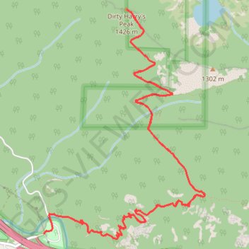
Dirty Harry's Peak Trail in Middle Fork Snoqualmie Natural Resources Conservation Area
The Dirty Harry's Peak Trail offers a vigorous and rewarding hike through the Middle Fork Snoqualmie Natural Resources Conservation Area. The route begins by climbing steadily through dense forests, eventually breaking into rocky terrain with expansive views of the surrounding peaks and valleys. From the summit, hikers are treated to panoramic vistas of the Middle Fork Snoqualmie Valley, Mount Rainier, and other parts of the Cascades. The trail's steep ascent and challenging rocky sections are ideal for experienced hikers looking for solitude and dramatic scenery. #Hiking #Mountain #Forest #Nature
- Distance: 8.0 mi
- Elevation gain: 3,547 ft
- Maximum elevation: 4,567 ft
- Elevation loss: 3,547 ft
- Minimum elevation: 1,312 ft
Interactive trail map
Make a donation
Gear up for your next adventure:
As an Amazon Associate, this site earns from qualifying purchases at no extra cost to you.
Trail profile
- Distance: 8.0 mi
- Elevation gain: 3,547 ft
- Maximum elevation: 4,567 ft
- Elevation loss: 3,547 ft
- Minimum elevation: 1,312 ft
Make a donation
Gear up for your next adventure:
As an Amazon Associate, this site earns from qualifying purchases at no extra cost to you.
About this trail
Name: Dirty Harry's Peak Trail in Middle Fork Snoqualmie Natural Resources Conservation Area trail, distance, elevation, map, profile, GPS track
Coordinates: 47.43066 -121.63249 47.45125 -121.61123
Topography: King County topographic map, elevation, terrain
Make a donation
Gear up for your next adventure:
As an Amazon Associate, this site earns from qualifying purchases at no extra cost to you.
Other hiking, mountain biking, running and outdoor activity trails
Click on a trail to view its statistics, map and profile.
Dirty Harry's Balcony in Middle Fork Snoqualmie Natural Resources Conservation Area
United States > Washington > King County
Dirty Harry's Balcony, nestled within the Middle Fork Snoqualmie Natural Resources Conservation Area, offers hikers a rewarding journey through dense forests adorned with towering conifers and lush undergrowth. As you ascend the Dirty Harry's Peak Trail, remnants of the area's logging history, such as old…
Distance: 4.5 mi • Elevation gain: 1,568 ft • Maximum elevation: 2,579 ft
Northern part of the Pacific Crest Trail (PCT)
United States > Oregon > Klamath County
Hike on the Pacific Crest National Scenic Trail from Crater Lake to Canada Border through Oregon and Washington along the Sierra Nevada and Cascade mountain ranges. #Hiking #Mountain #SierraNevada #Cascade #Nature #Forest #Park #PCT
Distance: 744.6 mi • Elevation gain: 145,367 ft • Maximum elevation: 7,569 ft
Dirty Harry's Peak Trail
United States > Washington > King County
Distance: 8.7 mi • Elevation gain: 3,596 ft • Maximum elevation: 4,570 ft
Make a donation
Gear up for your next adventure:
As an Amazon Associate, this site earns from qualifying purchases at no extra cost to you.