Make a donation
Gear up for your next adventure:
As an Amazon Associate, this site earns from qualifying purchases at no extra cost to you.
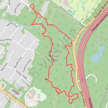
Tenafly Nature Center trails loop
- Distance: 3.2 mi
- Elevation gain: 108 ft
- Maximum elevation: 449 ft
- Elevation loss: 115 ft
- Minimum elevation: 397 ft
- Moving time: 59 m 6 s
- Moving speed: 3.2 mph
- Maximum speed: 5.7 mph
- Total time: 1 h 5 m
- Global speed: 2.9 mph
Interactive trail map
Make a donation
Gear up for your next adventure:
As an Amazon Associate, this site earns from qualifying purchases at no extra cost to you.
Trail profile
- Distance: 3.2 mi
- Elevation gain: 108 ft
- Maximum elevation: 449 ft
- Elevation loss: 115 ft
- Minimum elevation: 397 ft
- Moving time: 59 m 6 s
- Moving speed: 3.2 mph
- Maximum speed: 5.7 mph
- Total time: 1 h 5 m
- Global speed: 2.9 mph
Make a donation
Gear up for your next adventure:
As an Amazon Associate, this site earns from qualifying purchases at no extra cost to you.
About this trail
Name: Tenafly Nature Center trails loop trail, distance, elevation, map, profile, GPS track
Start: Yellow, Tenafly, Bergen County, New Jersey, 07670, United States (40.92438 -73.94450)
End: Yellow, Tenafly, Bergen County, New Jersey, 07670, United States (40.92447 -73.94467)
Coordinates: 40.91155 -73.94467 40.92483 -73.93613
Topography: Bergen County topographic map, elevation, terrain
Make a donation
Gear up for your next adventure:
As an Amazon Associate, this site earns from qualifying purchases at no extra cost to you.
Other hiking, mountain biking, running and outdoor activity trails
Click on a trail to view its statistics, map and profile.