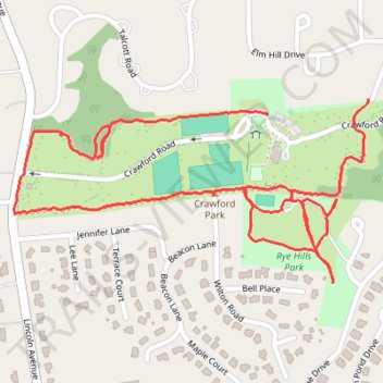
Crawford / Rye Hills parks loop
- Distance: 1.7 mi
- Elevation gain: 131 ft
- Maximum elevation: 213 ft
- Elevation loss: 125 ft
- Minimum elevation: 118 ft
- Moving time: 31 m 20 s
- Moving speed: 3.2 mph
- Maximum speed: 6.4 mph
- Total time: 32 m 4 s
- Global speed: 3.1 mph
Interactive trail map
Trail profile
- Distance: 1.7 mi
- Elevation gain: 131 ft
- Maximum elevation: 213 ft
- Elevation loss: 125 ft
- Minimum elevation: 118 ft
- Moving time: 31 m 20 s
- Moving speed: 3.2 mph
- Maximum speed: 6.4 mph
- Total time: 32 m 4 s
- Global speed: 3.1 mph
About this trail
Name: Crawford / Rye Hills parks loop trail, distance, elevation, map, profile, GPS track
Coordinates: 41.01252 -73.69151 41.01565 -73.68355
Topography: Westchester County topographic map, elevation, terrain
Other hiking, mountain biking, running and outdoor activity trails
Click on a trail to view its statistics, map and profile.