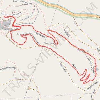
Loop walk via Virgin Valley, Silver Mine Track, DeVeg and Living on the quarry edge in Anstey Hill Recreation Park
- Distance: 2.1 mi
- Elevation gain: 390 ft
- Maximum elevation: 1,257 ft
- Elevation loss: 394 ft
- Minimum elevation: 886 ft
- Moving time: 48 m 27 s
- Moving speed: 2.7 mph
- Maximum speed: 4.4 mph
- Total time: 49 m 2 s
- Global speed: 2.6 mph
Interactive trail map
Trail profile
- Distance: 2.1 mi
- Elevation gain: 390 ft
- Maximum elevation: 1,257 ft
- Elevation loss: 394 ft
- Minimum elevation: 886 ft
- Moving time: 48 m 27 s
- Moving speed: 2.7 mph
- Maximum speed: 4.4 mph
- Total time: 49 m 2 s
- Global speed: 2.6 mph
About this trail
Name: Loop walk via Virgin Valley, Silver Mine Track, DeVeg and Living on the quarry edge in Anstey Hill Recreation Park trail, distance, elevation, map, profile, GPS track
Coordinates: -34.82985 138.73358 -34.82438 138.74265
Other hiking, mountain biking, running and outdoor activity trails
Click on a trail to view its statistics, map and profile.