Anstey Hill Recreation Park
Interactive trail map
Trail profile
- Distance: 3.4 mi
- Elevation gain: 620 ft
- Maximum elevation: 1,273 ft
- Elevation loss: 620 ft
- Minimum elevation: 748 ft
- Moving time: 1 h 10 m
- Moving speed: 2.9 mph
- Maximum speed: 4.4 mph
- Total time: 1 h 12 m
- Global speed: 2.8 mph
About this trail
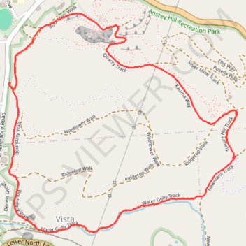
Name: Anstey Hill Recreation Park trail, distance, elevation, map, profile, GPS track
Coordinates: -34.83664 138.72692 -34.82380 138.74316
Other hiking, mountain biking, running and outdoor activity trails
Click on a trail to view its statistics, map and profile.
Loop walk via Virgin Valley, Silver Mine Track, DeVeg and Living on the quarry edge in Anstey Hill Recreation Park
Australia > South Australia > Adelaide
Distance: 2.1 mi • Elevation gain: 390 ft • Maximum elevation: 1,257 ft
Dry Creek to the Triangle
Australia > South Australia > Adelaide
Distance: 13.2 mi • Elevation gain: 571 ft • Maximum elevation: 669 ft
Dry Creek Trail
Australia > South Australia > Adelaide
Distance: 14.0 mi • Elevation gain: 863 ft • Maximum elevation: 669 ft