Make a donation
Gear up for your next adventure:
As an Amazon Associate, this site earns from qualifying purchases at no extra cost to you.
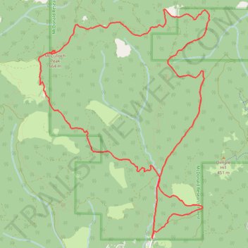
McCulloch Peak Loop Hike in McDonald Forest
- Distance: 9.3 mi
- Elevation gain: 2,205 ft
- Maximum elevation: 2,113 ft
- Elevation loss: 2,205 ft
- Minimum elevation: 486 ft
- Moving time: 3 h 5 m
- Moving speed: 3.0 mph
- Maximum speed: 6.7 mph
- Total time: 3 h 14 m
- Global speed: 2.9 mph
Interactive trail map
Make a donation
Gear up for your next adventure:
As an Amazon Associate, this site earns from qualifying purchases at no extra cost to you.
Trail profile
- Distance: 9.3 mi
- Elevation gain: 2,205 ft
- Maximum elevation: 2,113 ft
- Elevation loss: 2,205 ft
- Minimum elevation: 486 ft
- Moving time: 3 h 5 m
- Moving speed: 3.0 mph
- Maximum speed: 6.7 mph
- Total time: 3 h 14 m
- Global speed: 2.9 mph
Make a donation
Gear up for your next adventure:
As an Amazon Associate, this site earns from qualifying purchases at no extra cost to you.
About this trail
Name: McCulloch Peak Loop Hike in McDonald Forest trail, distance, elevation, map, profile, GPS track
Coordinates: 44.60318 -123.35537 44.63579 -123.32128
Topography: Benton County topographic map, elevation, terrain
Make a donation
Gear up for your next adventure:
As an Amazon Associate, this site earns from qualifying purchases at no extra cost to you.
Other hiking, mountain biking, running and outdoor activity trails
Click on a trail to view its statistics, map and profile.
MacDonald Forest Trail Run 50K 2026
United States > Oregon > Benton County
Distance: 32.6 mi • Elevation gain: 7,221 ft • Maximum elevation: 2,113 ft
Trails and roads around Dunn Forest
United States > Oregon > Benton County
Distance: 27.1 mi • Elevation gain: 4,974 ft • Maximum elevation: 1,873 ft