Make a donation
Gear up for your next adventure:
As an Amazon Associate, this site earns from qualifying purchases at no extra cost to you.
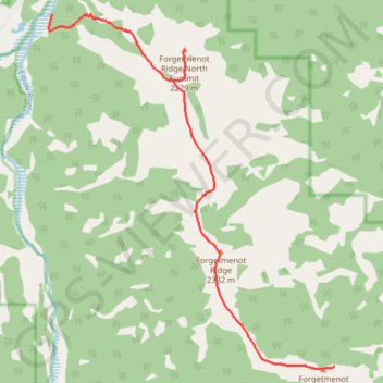
Elbow River - Forgetmenot Ridge - Forgetmenot Mountain
- Distance: 6.2 mi
- Elevation gain: 3,176 ft
- Maximum elevation: 7,631 ft
- Elevation loss: 846 ft
- Minimum elevation: 5,249 ft
Interactive trail map
Make a donation
Gear up for your next adventure:
As an Amazon Associate, this site earns from qualifying purchases at no extra cost to you.
Trail profile
- Distance: 6.2 mi
- Elevation gain: 3,176 ft
- Maximum elevation: 7,631 ft
- Elevation loss: 846 ft
- Minimum elevation: 5,249 ft
Make a donation
Gear up for your next adventure:
As an Amazon Associate, this site earns from qualifying purchases at no extra cost to you.
About this trail
Name: Elbow River - Forgetmenot Ridge - Forgetmenot Mountain trail, distance, elevation, map, profile, GPS track
Start: Wildhorse Trail, Kananaskis Improvement District, Alberta, Canada (50.79956 -114.84047)
End: Forgetmenot Mt, Kananaskis Improvement District, Alberta, Canada (50.75272 -114.78107)
Coordinates: 50.75245 -114.84123 50.79957 -114.78107
Make a donation
Gear up for your next adventure:
As an Amazon Associate, this site earns from qualifying purchases at no extra cost to you.
Other hiking, mountain biking, running and outdoor activity trails
Click on a trail to view its statistics, map and profile.
Little Elbow to Big Elbow Campground
Canada > Alberta > Kananaskis Improvement District
Distance: 11.5 mi • Elevation gain: 640 ft • Maximum elevation: 5,673 ft
12-OCT-21 16:57:46
Canada > Alberta > Kananaskis Improvement District
Distance: 16.5 mi • Elevation gain: 3,537 ft • Maximum elevation: 7,641 ft