Make a donation
Gear up for your next adventure:
As an Amazon Associate, this site earns from qualifying purchases at no extra cost to you.
12-OCT-21 16:57:46
- Distance: 16.5 mi
- Elevation gain: 3,537 ft
- Maximum elevation: 7,641 ft
- Elevation loss: 3,537 ft
- Minimum elevation: 5,256 ft
- Moving time: 5 h 59 m
- Moving speed: 2.8 mph
- Maximum speed: 5.9 mph
- Total time: 7 h 18 m
- Global speed: 2.3 mph
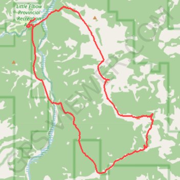
Interactive trail map
Make a donation
Gear up for your next adventure:
As an Amazon Associate, this site earns from qualifying purchases at no extra cost to you.
Trail profile
- Distance: 16.5 mi
- Elevation gain: 3,537 ft
- Maximum elevation: 7,641 ft
- Elevation loss: 3,537 ft
- Minimum elevation: 5,256 ft
- Moving time: 5 h 59 m
- Moving speed: 2.8 mph
- Maximum speed: 5.9 mph
- Total time: 7 h 18 m
- Global speed: 2.3 mph
Make a donation
Gear up for your next adventure:
As an Amazon Associate, this site earns from qualifying purchases at no extra cost to you.
About this trail
Name: 12-OCT-21 16:57:46 trail, distance, elevation, map, profile, GPS track
Start: Ford Knoll Loop, Kananaskis Improvement District, Alberta, Canada (50.79446 -114.85296)
End: Ford Knoll Loop, Kananaskis Improvement District, Alberta, Canada (50.79439 -114.85294)
Coordinates: 50.72861 -114.85841 50.79956 -114.77317
Make a donation
Gear up for your next adventure:
As an Amazon Associate, this site earns from qualifying purchases at no extra cost to you.
Other hiking, mountain biking, running and outdoor activity trails
Click on a trail to view its statistics, map and profile.
Elbow River - Forgetmenot Ridge - Forgetmenot Mountain
Canada > Alberta > Kananaskis Improvement District
Distance: 6.2 mi • Elevation gain: 3,176 ft • Maximum elevation: 7,631 ft
Little Elbow to Mount Romulus Campground
Canada > Alberta > Kananaskis Improvement District
Distance: 15.4 mi • Elevation gain: 1,217 ft • Maximum elevation: 5,942 ft
Little Elbow to Big Elbow Campground
Canada > Alberta > Kananaskis Improvement District
Distance: 11.5 mi • Elevation gain: 640 ft • Maximum elevation: 5,673 ft