Make a donation
Gear up for your next adventure:
As an Amazon Associate, this site earns from qualifying purchases at no extra cost to you.
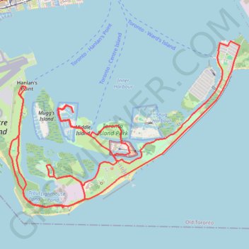
Toronto Islands Trail
Interactive trail map
Make a donation
Gear up for your next adventure:
As an Amazon Associate, this site earns from qualifying purchases at no extra cost to you.
Trail profile
- Distance: 10.5 mi
- Elevation gain: 148 ft
- Maximum elevation: 266 ft
- Elevation loss: 148 ft
- Minimum elevation: 240 ft
Make a donation
Gear up for your next adventure:
As an Amazon Associate, this site earns from qualifying purchases at no extra cost to you.
About this trail
Name: Toronto Islands Trail trail, distance, elevation, map, profile, GPS track
Coordinates: 43.61301 -79.39212 43.63330 -79.35322
Make a donation
Gear up for your next adventure:
As an Amazon Associate, this site earns from qualifying purchases at no extra cost to you.
Other hiking, mountain biking, running and outdoor activity trails
Click on a trail to view its statistics, map and profile.
Biidaasige Park and Tommy Thompson Park Loop Ride
Distance: 12.7 mi • Elevation gain: 220 ft • Maximum elevation: 269 ft
Make a donation
Gear up for your next adventure:
As an Amazon Associate, this site earns from qualifying purchases at no extra cost to you.
Brampton - Scarborough
Canada > Ontario > Peel Region > Brampton
Lake Ontario. #Bike #Brampton #Scarborough #Toronto #Ontario
Distance: 45.5 mi • Elevation gain: 1,870 ft • Maximum elevation: 604 ft
Make a donation
Gear up for your next adventure:
As an Amazon Associate, this site earns from qualifying purchases at no extra cost to you.
Hamilton - Toronto
#Bike
Distance: 50.5 mi • Elevation gain: 1,503 ft • Maximum elevation: 364 ft