Make a donation
Gear up for your next adventure:
As an Amazon Associate, this site earns from qualifying purchases at no extra cost to you.
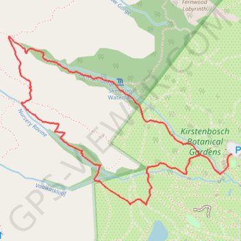
Skeleton Gorge - Nursery Ravine
Interactive trail map
Make a donation
Gear up for your next adventure:
As an Amazon Associate, this site earns from qualifying purchases at no extra cost to you.
Trail profile
- Distance: 3.4 mi
- Elevation gain: 2,060 ft
- Maximum elevation: 2,477 ft
- Elevation loss: 2,064 ft
- Minimum elevation: 449 ft
Make a donation
Gear up for your next adventure:
As an Amazon Associate, this site earns from qualifying purchases at no extra cost to you.
About this trail
Name: Skeleton Gorge - Nursery Ravine trail, distance, elevation, map, profile, GPS track
Coordinates: -33.98955 18.41559 -33.97912 18.43217
Make a donation
Gear up for your next adventure:
As an Amazon Associate, this site earns from qualifying purchases at no extra cost to you.
Other hiking, mountain biking, running and outdoor activity trails
Click on a trail to view its statistics, map and profile.
Table Mountain traverse from Kloof Corner to Suikerbossie via Maclear's Beacon
South Africa > Western Cape > City of Cape Town > Cape Town
Distance: 12.9 mi • Elevation gain: 4,957 ft • Maximum elevation: 3,533 ft
Simon's Town - Cape Town
South Africa > Western Cape > City of Cape Town > Simon's Town
#Bike
Distance: 33.5 mi • Elevation gain: 3,698 ft • Maximum elevation: 604 ft
Route von Longmarket Street nach/zu Rhodesrylaan
South Africa > Western Cape > City of Cape Town > Cape Town
Distance: 7.7 mi • Elevation gain: 489 ft • Maximum elevation: 374 ft