Make a donation
Gear up for your next adventure:
As an Amazon Associate, this site earns from qualifying purchases at no extra cost to you.
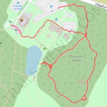
Tracked with OSMTracker for Android™
- Distance: 0.7 mi
- Elevation gain: 49 ft
- Maximum elevation: 584 ft
- Elevation loss: 52 ft
- Minimum elevation: 545 ft
- Moving time: 20 m 42 s
- Moving speed: 2.2 mph
- Maximum speed: 3.8 mph
- Total time: 20 m 42 s
- Global speed: 2.2 mph
Interactive trail map
Make a donation
Gear up for your next adventure:
As an Amazon Associate, this site earns from qualifying purchases at no extra cost to you.
Trail profile
- Distance: 0.7 mi
- Elevation gain: 49 ft
- Maximum elevation: 584 ft
- Elevation loss: 52 ft
- Minimum elevation: 545 ft
- Moving time: 20 m 42 s
- Moving speed: 2.2 mph
- Maximum speed: 3.8 mph
- Total time: 20 m 42 s
- Global speed: 2.2 mph
Make a donation
Gear up for your next adventure:
As an Amazon Associate, this site earns from qualifying purchases at no extra cost to you.
About this trail
Name: Tracked with OSMTracker for Android™ trail, distance, elevation, map, profile, GPS track
Coordinates: 55.97023 -4.33135 55.97294 -4.32712
Make a donation
Gear up for your next adventure:
As an Amazon Associate, this site earns from qualifying purchases at no extra cost to you.
Other hiking, mountain biking, running and outdoor activity trails
Click on a trail to view its statistics, map and profile.
2026-06-26_10-27_Fri
United Kingdom > Scotland > Stirling > Blanefield > Craigallian
Distance: 0.7 mi • Elevation gain: 49 ft • Maximum elevation: 584 ft
West Highland Way between Milngavie and Craigallian Loch
United Kingdom > Scotland > East Dunbartonshire > Milngavie
Distance: 4.6 mi • Elevation gain: 272 ft • Maximum elevation: 384 ft
Loop walk in Mugdock County Park
United Kingdom > Scotland > Stirling > Mugdock
Distance: 2.9 mi • Elevation gain: 144 ft • Maximum elevation: 587 ft
Make a donation
Gear up for your next adventure:
As an Amazon Associate, this site earns from qualifying purchases at no extra cost to you.