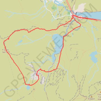
Llyn Ogwyn, Devil's Kitchen and Y Garn circuit
- Distance: 5.7 mi
- Elevation gain: 2,438 ft
- Maximum elevation: 3,058 ft
- Elevation loss: 2,441 ft
- Minimum elevation: 997 ft
- Moving time: 3 h 48 m
- Moving speed: 1.5 mph
- Maximum speed: 3.6 mph
- Total time: 7 h 4 m
- Global speed: 0.8 mph
Interactive trail map
Trail profile
- Distance: 5.7 mi
- Elevation gain: 2,438 ft
- Maximum elevation: 3,058 ft
- Elevation loss: 2,441 ft
- Minimum elevation: 997 ft
- Moving time: 3 h 48 m
- Moving speed: 1.5 mph
- Maximum speed: 3.6 mph
- Total time: 7 h 4 m
- Global speed: 0.8 mph
About this trail
Name: Llyn Ogwyn, Devil's Kitchen and Y Garn circuit trail, distance, elevation, map, profile, GPS track
Start: A5, Capel Curig, Conwy, Wales, LL57 3LZ, United Kingdom (53.12231 -4.00970)
End: A5, Capel Curig, Conwy, Wales, LL57 3LZ, United Kingdom (53.12269 -4.01314)
Coordinates: 53.10642 -4.04764 53.12344 -4.00970
Other hiking, mountain biking, running and outdoor activity trails
Click on a trail to view its statistics, map and profile.
Hillwalk Tryfan Glyder Fach Fawr Garn Elidir Fawr
United Kingdom > Wales > Conwy
Hillwalk, Tryfan, Glyder, Fach, Fawr, Garn, Elidir, Fawr
Distance: 9.5 mi • Elevation gain: 4,452 ft • Maximum elevation: 3,245 ft
Ultra-Trail Snowdonia Eryri UTS 100M
United Kingdom > Wales > Gwynedd > Llanberis
Distance: 101.4 mi • Elevation gain: 31,837 ft • Maximum elevation: 3,471 ft