Make a donation
Gear up for your next adventure:
As an Amazon Associate, this site earns from qualifying purchases at no extra cost to you.
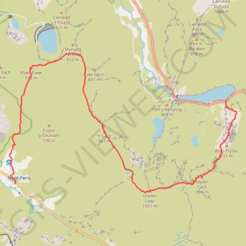
Hillwalk Tryfan Glyder Fach Fawr Garn Elidir Fawr
Hillwalk, Tryfan, Glyder, Fach, Fawr, Garn, Elidir, Fawr
- Distance: 9.5 mi
- Elevation gain: 4,452 ft
- Maximum elevation: 3,245 ft
- Elevation loss: 5,092 ft
- Minimum elevation: 361 ft
- Moving time: 5 h 52 m
- Moving speed: 1.6 mph
- Maximum speed: 3.9 mph
- Total time: 8 h 1 m
- Global speed: 1.2 mph
Interactive trail map
Make a donation
Gear up for your next adventure:
As an Amazon Associate, this site earns from qualifying purchases at no extra cost to you.
Trail profile
- Distance: 9.5 mi
- Elevation gain: 4,452 ft
- Maximum elevation: 3,245 ft
- Elevation loss: 5,092 ft
- Minimum elevation: 361 ft
- Moving time: 5 h 52 m
- Moving speed: 1.6 mph
- Maximum speed: 3.9 mph
- Total time: 8 h 1 m
- Global speed: 1.2 mph
Make a donation
Gear up for your next adventure:
As an Amazon Associate, this site earns from qualifying purchases at no extra cost to you.
About this trail
Name: Hillwalk Tryfan Glyder Fach Fawr Garn Elidir Fawr trail, distance, elevation, map, profile, GPS track
Start: A5, Capel Curig, Conwy, Wales, LL57 3LZ, United Kingdom (53.12294 -3.99855)
Coordinates: 53.10096 -4.08469 53.13414 -3.99447
Make a donation
Gear up for your next adventure:
As an Amazon Associate, this site earns from qualifying purchases at no extra cost to you.
Other hiking, mountain biking, running and outdoor activity trails
Click on a trail to view its statistics, map and profile.
Llyn Ogwyn, Devil's Kitchen and Y Garn circuit
United Kingdom > Wales > Conwy
Distance: 5.7 mi • Elevation gain: 2,438 ft • Maximum elevation: 3,058 ft
Hillwalk Carnedd Dafydd LLewelyn Foel-fras
United Kingdom > Wales > Conwy
Distance: 13.0 mi • Elevation gain: 4,137 ft • Maximum elevation: 3,478 ft
Ultra-Trail Snowdonia Eryri UTS 100M
United Kingdom > Wales > Gwynedd > Llanberis
Distance: 101.4 mi • Elevation gain: 31,837 ft • Maximum elevation: 3,471 ft