Thank you for supporting this site ❤️
Make a donation
Make a donation
Gear up for your next adventure:
As an Amazon Associate, this site earns from qualifying purchases at no extra cost to you.
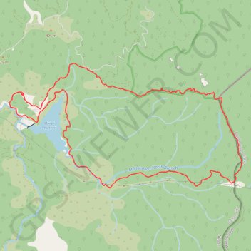
Maungatapu - Saddle Hill loop
- Distance: 11.0 mi
- Elevation gain: 4,364 ft
- Maximum elevation: 3,812 ft
- Elevation loss: 4,360 ft
- Minimum elevation: 407 ft
- Moving time: 4 h 4 m
- Moving speed: 2.7 mph
- Maximum speed: 12.1 mph
- Total time: 4 h 34 m
- Global speed: 2.4 mph
Interactive trail map
Thank you for supporting this site ❤️
Make a donation
Make a donation
Gear up for your next adventure:
As an Amazon Associate, this site earns from qualifying purchases at no extra cost to you.
Trail profile
- Distance: 11.0 mi
- Elevation gain: 4,364 ft
- Maximum elevation: 3,812 ft
- Elevation loss: 4,360 ft
- Minimum elevation: 407 ft
- Moving time: 4 h 4 m
- Moving speed: 2.7 mph
- Maximum speed: 12.1 mph
- Total time: 4 h 34 m
- Global speed: 2.4 mph
Thank you for supporting this site ❤️
Make a donation
Make a donation
Gear up for your next adventure:
As an Amazon Associate, this site earns from qualifying purchases at no extra cost to you.
About this trail
Name: Maungatapu - Saddle Hill loop trail, distance, elevation, map, profile, GPS track
Start: Maitai Valley Road, Nelson, New Zealand (-41.29042 173.36558)
End: Maitai Valley Road, Nelson, New Zealand (-41.29037 173.36561)
Coordinates: -41.30501 173.36543 -41.28263 173.42104
Thank you for supporting this site ❤️
Make a donation
Make a donation
Gear up for your next adventure:
As an Amazon Associate, this site earns from qualifying purchases at no extra cost to you.
Other hiking, mountain biking, running and outdoor activity trails
Click on a trail to view its statistics, map and profile.