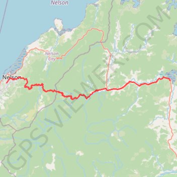
Havelock - Nelson
Interactive trail map
Trail profile
- Distance: 38.5 mi
- Elevation gain: 5,407 ft
- Maximum elevation: 2,441 ft
- Elevation loss: 5,390 ft
- Minimum elevation: 3 ft
About this trail
Name: Havelock - Nelson trail, distance, elevation, map, profile, GPS track
Start: Havelock Quay, Havelock, Marlborough District, Marlborough, 7100, New Zealand (-41.28014 173.76754)
Coordinates: -41.32246 173.26861 -41.27197 173.76754
Other hiking, mountain biking, running and outdoor activity trails
Click on a trail to view its statistics, map and profile.
Loop around Centre of NZ, Maitai Valley, Branford Park
New Zealand > Nelson > Nelson
Distance: 5.2 mi • Elevation gain: 899 ft • Maximum elevation: 551 ft
Maungatapu - Saddle Hill loop
New Zealand > Nelson > Nelson
Distance: 11.0 mi • Elevation gain: 4,364 ft • Maximum elevation: 3,812 ft
Takorika Summit loop - Havelock
New Zealand > Marlborough > Marlborough District > Havelock
Distance: 6.2 mi • Elevation gain: 2,487 ft • Maximum elevation: 2,310 ft
Nelson, Maitai Valley
New Zealand > Nelson > Nelson
Distance: 10.9 mi • Elevation gain: 1,535 ft • Maximum elevation: 554 ft