Thank you for supporting this site ❤️
Make a donation
Make a donation
Gear up for your next adventure:
As an Amazon Associate, this site earns from qualifying purchases at no extra cost to you.
Cosgrave Reservoir - Goldfields
- Distance: 6.0 mi
- Elevation gain: 607 ft
- Maximum elevation: 1,847 ft
- Elevation loss: 610 ft
- Minimum elevation: 1,542 ft
- Moving time: 2 h 13 m
- Moving speed: 2.7 mph
- Maximum speed: 3.5 mph
- Total time: 3 h 7 m
- Global speed: 1.9 mph
Interactive trail map
Thank you for supporting this site ❤️
Make a donation
Make a donation
Gear up for your next adventure:
As an Amazon Associate, this site earns from qualifying purchases at no extra cost to you.
Trail profile
- Distance: 6.0 mi
- Elevation gain: 607 ft
- Maximum elevation: 1,847 ft
- Elevation loss: 610 ft
- Minimum elevation: 1,542 ft
- Moving time: 2 h 13 m
- Moving speed: 2.7 mph
- Maximum speed: 3.5 mph
- Total time: 3 h 7 m
- Global speed: 1.9 mph
Thank you for supporting this site ❤️
Make a donation
Make a donation
Gear up for your next adventure:
As an Amazon Associate, this site earns from qualifying purchases at no extra cost to you.
About this trail
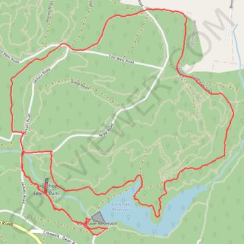
Name: Cosgrave Reservoir - Goldfields trail, distance, elevation, map, profile, GPS track
Start: Creswick, Shire of Hepburn, Victoria, 3363, Australia (-37.44469 143.93615)
End: Creswick, Shire of Hepburn, Victoria, 3363, Australia (-37.44467 143.93615)
Coordinates: -37.44520 143.92696 -37.42804 143.94828
Thank you for supporting this site ❤️
Make a donation
Make a donation
Gear up for your next adventure:
As an Amazon Associate, this site earns from qualifying purchases at no extra cost to you.
Other hiking, mountain biking, running and outdoor activity trails
Click on a trail to view its statistics, map and profile.