Make a donation
Gear up for your next adventure:
As an Amazon Associate, this site earns from qualifying purchases at no extra cost to you.
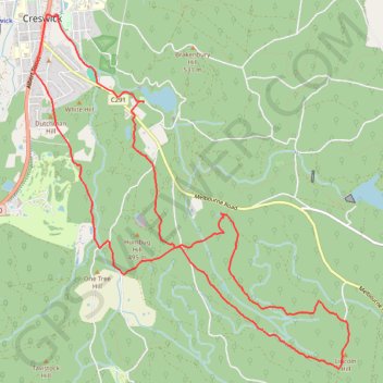
Creswick State Forest
Interactive trail map
Make a donation
Gear up for your next adventure:
As an Amazon Associate, this site earns from qualifying purchases at no extra cost to you.
Trail profile
- Distance: 9.4 mi
- Elevation gain: 778 ft
- Maximum elevation: 1,893 ft
- Elevation loss: 778 ft
- Minimum elevation: 1,385 ft
Make a donation
Gear up for your next adventure:
As an Amazon Associate, this site earns from qualifying purchases at no extra cost to you.
About this trail
Name: Creswick State Forest trail, distance, elevation, map, profile, GPS track
Start: Saint Georges Street, Creswick, Shire of Hepburn, Victoria, 3363, Australia (-37.43355 143.90765)
End: Saint Georges Street, Creswick, Shire of Hepburn, Victoria, 3363, Australia (-37.43353 143.90765)
Coordinates: -37.46202 143.89288 -37.42421 143.93520
Make a donation
Gear up for your next adventure:
As an Amazon Associate, this site earns from qualifying purchases at no extra cost to you.
Other hiking, mountain biking, running and outdoor activity trails
Click on a trail to view its statistics, map and profile.
Cosgrave Reservoir - Goldfields
Australia > Victoria > Creswick
Distance: 6.0 mi • Elevation gain: 607 ft • Maximum elevation: 1,847 ft