Make a donation
Gear up for your next adventure:
As an Amazon Associate, this site earns from qualifying purchases at no extra cost to you.
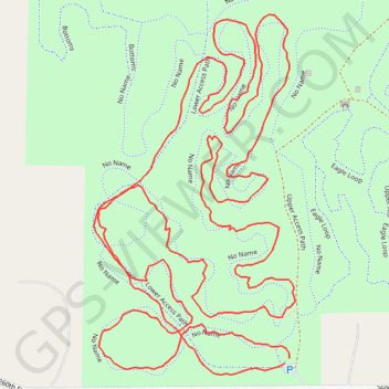
Ingawanis Woodland trails
- Distance: 2.4 mi
- Elevation gain: 131 ft
- Maximum elevation: 955 ft
- Elevation loss: 135 ft
- Minimum elevation: 915 ft
- Moving time: 1 h 6 m
- Moving speed: 2.1 mph
- Maximum speed: 5.2 mph
- Total time: 1 h 8 m
- Global speed: 2.1 mph
Interactive trail map
Make a donation
Gear up for your next adventure:
As an Amazon Associate, this site earns from qualifying purchases at no extra cost to you.
Trail profile
- Distance: 2.4 mi
- Elevation gain: 131 ft
- Maximum elevation: 955 ft
- Elevation loss: 135 ft
- Minimum elevation: 915 ft
- Moving time: 1 h 6 m
- Moving speed: 2.1 mph
- Maximum speed: 5.2 mph
- Total time: 1 h 8 m
- Global speed: 2.1 mph
Make a donation
Gear up for your next adventure:
As an Amazon Associate, this site earns from qualifying purchases at no extra cost to you.
About this trail
Name: Ingawanis Woodland trails trail, distance, elevation, map, profile, GPS track
Start: Lower Access Path, Bremer County, Iowa, United States (42.67182 -92.42118)
End: Upper Access Path, Bremer County, Iowa, United States (42.67175 -92.42127)
Coordinates: 42.67161 -92.42462 42.67626 -92.42108
Topography: Bremer County topographic map, elevation, terrain
Make a donation
Gear up for your next adventure:
As an Amazon Associate, this site earns from qualifying purchases at no extra cost to you.
Other hiking, mountain biking, running and outdoor activity trails
Click on a trail to view its statistics, map and profile.
Ingawanis Woodland trails
United States > Iowa > Bremer County
Distance: 4.6 mi • Elevation gain: 236 ft • Maximum elevation: 974 ft
Ingawanis Woodland Loop
United States > Iowa > Bremer County
Distance: 3.0 mi • Elevation gain: 203 ft • Maximum elevation: 988 ft
Ingawanis Woodland
United States > Iowa > Bremer County
Distance: 2.1 mi • Elevation gain: 138 ft • Maximum elevation: 974 ft