Make a donation
Gear up for your next adventure:
As an Amazon Associate, this site earns from qualifying purchases at no extra cost to you.
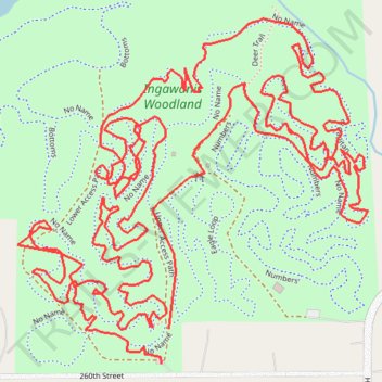
Ingawanis Woodland trails
- Distance: 4.6 mi
- Elevation gain: 236 ft
- Maximum elevation: 974 ft
- Elevation loss: 220 ft
- Minimum elevation: 909 ft
Interactive trail map
Make a donation
Gear up for your next adventure:
As an Amazon Associate, this site earns from qualifying purchases at no extra cost to you.
Trail profile
- Distance: 4.6 mi
- Elevation gain: 236 ft
- Maximum elevation: 974 ft
- Elevation loss: 220 ft
- Minimum elevation: 909 ft
Make a donation
Gear up for your next adventure:
As an Amazon Associate, this site earns from qualifying purchases at no extra cost to you.
About this trail
Name: Ingawanis Woodland trails trail, distance, elevation, map, profile, GPS track
Start: Upper Access Path, Bremer County, Iowa, United States (42.67162 -92.42114)
End: Upper Access Path, Bremer County, Iowa, United States (42.67227 -92.42096)
Coordinates: 42.67162 -92.42484 42.67800 -92.41596
Topography: Bremer County topographic map, elevation, terrain
Make a donation
Gear up for your next adventure:
As an Amazon Associate, this site earns from qualifying purchases at no extra cost to you.
Other hiking, mountain biking, running and outdoor activity trails
Click on a trail to view its statistics, map and profile.
Ingawanis Woodland trails
United States > Iowa > Bremer County
Distance: 2.4 mi • Elevation gain: 131 ft • Maximum elevation: 955 ft
Ingawanis Woodland Loop
United States > Iowa > Bremer County
Distance: 3.0 mi • Elevation gain: 203 ft • Maximum elevation: 988 ft
Ingawanis Woodland
United States > Iowa > Bremer County
Distance: 2.1 mi • Elevation gain: 138 ft • Maximum elevation: 974 ft