Make a donation
Gear up for your next adventure:
As an Amazon Associate, this site earns from qualifying purchases at no extra cost to you.
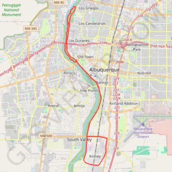
Rio Grande Bosque Loop
Loop bike / MTB through the Rio Grande Bosque via Paseo Del Bosque Trail, Central Pond, Riverside Trail and Chavez Loop along the Rio Grande in Albuquerque. #Bike #MTB #Loop #River #Nature #Forest #Park #Lake #City
- Distance: 24.2 mi
- Elevation gain: 591 ft
- Maximum elevation: 4,997 ft
- Elevation loss: 591 ft
- Minimum elevation: 4,928 ft
- Moving time: 2 h 10 m
- Moving speed: 11.1 mph
- Maximum speed: 18.6 mph
- Total time: 2 h 34 m
- Global speed: 9.4 mph
Interactive trail map
Make a donation
Gear up for your next adventure:
As an Amazon Associate, this site earns from qualifying purchases at no extra cost to you.
Trail profile
- Distance: 24.2 mi
- Elevation gain: 591 ft
- Maximum elevation: 4,997 ft
- Elevation loss: 591 ft
- Minimum elevation: 4,928 ft
- Moving time: 2 h 10 m
- Moving speed: 11.1 mph
- Maximum speed: 18.6 mph
- Total time: 2 h 34 m
- Global speed: 9.4 mph
Make a donation
Gear up for your next adventure:
As an Amazon Associate, this site earns from qualifying purchases at no extra cost to you.
About this trail
Name: Rio Grande Bosque Loop trail, distance, elevation, map, profile, GPS track
Coordinates: 35.00237 -106.69211 35.13776 -106.64812
Topography: Albuquerque topographic map, elevation, terrain
Make a donation
Gear up for your next adventure:
As an Amazon Associate, this site earns from qualifying purchases at no extra cost to you.