Make a donation
Gear up for your next adventure:
As an Amazon Associate, this site earns from qualifying purchases at no extra cost to you.
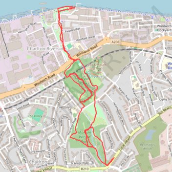
Maryon Wilson Park to Thames Barrier Loop
Loop hike from Cemetery Lane to Maryon Wilson Park, Maryon Park, Moore Park and Thames Barrier. #Hiking #Loop #London #Park #Nature #River #City #Forest
- Distance: 3.6 mi
- Elevation gain: 292 ft
- Maximum elevation: 148 ft
- Elevation loss: 295 ft
- Minimum elevation: 3 ft
- Moving time: 1 h 24 m
- Moving speed: 2.5 mph
- Maximum speed: 5.0 mph
- Total time: 1 h 32 m
- Global speed: 2.3 mph
Interactive trail map
Make a donation
Gear up for your next adventure:
As an Amazon Associate, this site earns from qualifying purchases at no extra cost to you.
Trail profile
- Distance: 3.6 mi
- Elevation gain: 292 ft
- Maximum elevation: 148 ft
- Elevation loss: 295 ft
- Minimum elevation: 3 ft
- Moving time: 1 h 24 m
- Moving speed: 2.5 mph
- Maximum speed: 5.0 mph
- Total time: 1 h 32 m
- Global speed: 2.3 mph
Make a donation
Gear up for your next adventure:
As an Amazon Associate, this site earns from qualifying purchases at no extra cost to you.
About this trail
Name: Maryon Wilson Park to Thames Barrier Loop trail, distance, elevation, map, profile, GPS track
Coordinates: 51.48228 0.03918 51.49544 0.04665
Make a donation
Gear up for your next adventure:
As an Amazon Associate, this site earns from qualifying purchases at no extra cost to you.
Other hiking, mountain biking, running and outdoor activity trails
Click on a trail to view its statistics, map and profile.
London Marathon
United Kingdom > England > London
Distance: 26.2 mi • Elevation gain: 922 ft • Maximum elevation: 164 ft