Thank you for supporting this site ❤️
Make a donation
Make a donation
Gear up for your next adventure:
As an Amazon Associate, this site earns from qualifying purchases at no extra cost to you.
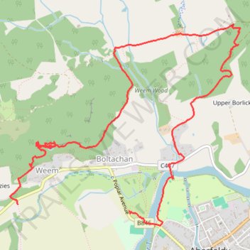
2026_05_13_1501Weem_loop
- Distance: 5.7 mi
- Elevation gain: 1,608 ft
- Maximum elevation: 994 ft
- Elevation loss: 1,614 ft
- Minimum elevation: 276 ft
- Moving time: 3 h 4 s
- Moving speed: 1.9 mph
- Maximum speed: 12.8 mph
- Total time: 4 h 5 m
- Global speed: 1.4 mph
Interactive trail map
Thank you for supporting this site ❤️
Make a donation
Make a donation
Gear up for your next adventure:
As an Amazon Associate, this site earns from qualifying purchases at no extra cost to you.
Trail profile
- Distance: 5.7 mi
- Elevation gain: 1,608 ft
- Maximum elevation: 994 ft
- Elevation loss: 1,614 ft
- Minimum elevation: 276 ft
- Moving time: 3 h 4 s
- Moving speed: 1.9 mph
- Maximum speed: 12.8 mph
- Total time: 4 h 5 m
- Global speed: 1.4 mph
Thank you for supporting this site ❤️
Make a donation
Make a donation
Gear up for your next adventure:
As an Amazon Associate, this site earns from qualifying purchases at no extra cost to you.
About this trail
Name: 2026_05_13_1501Weem_loop trail, distance, elevation, map, profile, GPS track
Coordinates: 56.62127 -3.89375 56.63710 -3.86072
Thank you for supporting this site ❤️
Make a donation
Make a donation
Gear up for your next adventure:
As an Amazon Associate, this site earns from qualifying purchases at no extra cost to you.
Other hiking, mountain biking, running and outdoor activity trails
Click on a trail to view its statistics, map and profile.
EMTB: Aberfeldy to Grandtully - Incl Rob Roy Way
United Kingdom > Scotland > Perth and Kinross > Aberfeldy
Loop
Distance: 12.5 mi • Elevation gain: 876 ft • Maximum elevation: 479 ft