Thank you for supporting this site ❤️
Make a donation
Make a donation
Gear up for your next adventure:
As an Amazon Associate, this site earns from qualifying purchases at no extra cost to you.
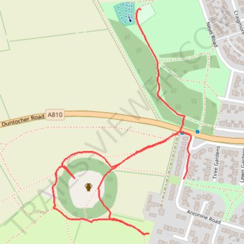
Castlehill Fort
- Distance: 1.0 mi
- Elevation gain: 98 ft
- Maximum elevation: 361 ft
- Elevation loss: 98 ft
- Minimum elevation: 315 ft
- Moving time: 29 m 32 s
- Moving speed: 2.1 mph
- Maximum speed: 3.9 mph
- Total time: 33 m 44 s
- Global speed: 1.9 mph
Interactive trail map
Thank you for supporting this site ❤️
Make a donation
Make a donation
Gear up for your next adventure:
As an Amazon Associate, this site earns from qualifying purchases at no extra cost to you.
Trail profile
- Distance: 1.0 mi
- Elevation gain: 98 ft
- Maximum elevation: 361 ft
- Elevation loss: 98 ft
- Minimum elevation: 315 ft
- Moving time: 29 m 32 s
- Moving speed: 2.1 mph
- Maximum speed: 3.9 mph
- Total time: 33 m 44 s
- Global speed: 1.9 mph
Thank you for supporting this site ❤️
Make a donation
Make a donation
Gear up for your next adventure:
As an Amazon Associate, this site earns from qualifying purchases at no extra cost to you.
About this trail
Name: Castlehill Fort trail, distance, elevation, map, profile, GPS track
Coordinates: 55.92356 -4.36451 55.92834 -4.35928
Thank you for supporting this site ❤️
Make a donation
Make a donation
Gear up for your next adventure:
As an Amazon Associate, this site earns from qualifying purchases at no extra cost to you.
Other hiking, mountain biking, running and outdoor activity trails
Click on a trail to view its statistics, map and profile.