Jasper National Park - Banff National Park
Interactive trail map
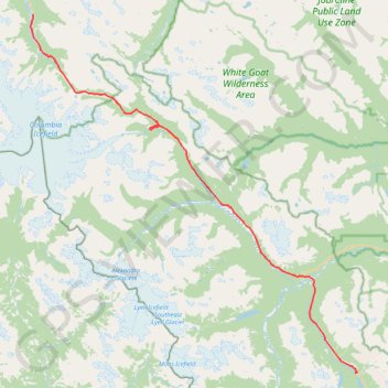
Trail profile
- Distance: 52.2 mi
- Elevation gain: 3,852 ft
- Maximum elevation: 6,791 ft
- Elevation loss: 3,543 ft
- Minimum elevation: 4,567 ft
About this trail
Name: Jasper National Park - Banff National Park trail, distance, elevation, map, profile, GPS track
Start: Icefields Parkway, Improvement District No. 12, Alberta, Canada (52.32423 -117.32859)
Coordinates: 51.84199 -117.33327 52.32423 -116.62016
Other hiking, mountain biking, running and outdoor activity trails
Click on a trail to view its statistics, map and profile.
Lake of the Falls
Canada > Alberta > Clearwater County
Lake of the Falls Natural Area. #Hiking
Distance: 10.5 mi • Elevation gain: 2,949 ft • Maximum elevation: 6,900 ft
Wilcox Pass Trail
Canada > Alberta > Improvement District No. 12
Distance: 5.1 mi • Elevation gain: 1,230 ft • Maximum elevation: 7,713 ft