Lake of the Falls
Lake of the Falls Natural Area. #Hiking
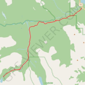
- Distance: 10.5 mi
- Elevation gain: 2,949 ft
- Maximum elevation: 6,900 ft
- Elevation loss: 512 ft
- Minimum elevation: 4,459 ft
Interactive trail map
Trail profile
- Distance: 10.5 mi
- Elevation gain: 2,949 ft
- Maximum elevation: 6,900 ft
- Elevation loss: 512 ft
- Minimum elevation: 4,459 ft
About this trail
Name: Lake of the Falls trail, distance, elevation, map, profile, GPS track
Start: Cline River Canyon Viewpoint, Clearwater County, Alberta, Canada (52.16704 -116.47853)
End: Lake of Falls Trail, Clearwater County, Alberta, Canada (52.08863 -116.62525)
Coordinates: 52.08863 -116.62525 52.16714 -116.47853
Other hiking, mountain biking, running and outdoor activity trails
Click on a trail to view its statistics, map and profile.