Thank you for supporting this site ❤️
Make a donation
Make a donation
Gear up for your next adventure:
As an Amazon Associate, this site earns from qualifying purchases at no extra cost to you.
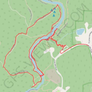
Eno River
- Distance: 3.5 mi
- Elevation gain: 223 ft
- Maximum elevation: 518 ft
- Elevation loss: 187 ft
- Minimum elevation: 417 ft
- Moving time: 1 h 29 m
- Moving speed: 2.3 mph
- Maximum speed: 31.2 mph
- Total time: 2 h 13 m
- Global speed: 1.6 mph
Interactive trail map
Thank you for supporting this site ❤️
Make a donation
Make a donation
Gear up for your next adventure:
As an Amazon Associate, this site earns from qualifying purchases at no extra cost to you.
Trail profile
- Distance: 3.5 mi
- Elevation gain: 223 ft
- Maximum elevation: 518 ft
- Elevation loss: 187 ft
- Minimum elevation: 417 ft
- Moving time: 1 h 29 m
- Moving speed: 2.3 mph
- Maximum speed: 31.2 mph
- Total time: 2 h 13 m
- Global speed: 1.6 mph
Thank you for supporting this site ❤️
Make a donation
Make a donation
Gear up for your next adventure:
As an Amazon Associate, this site earns from qualifying purchases at no extra cost to you.
About this trail
Name: Eno River trail, distance, elevation, map, profile, GPS track
Coordinates: 36.07423 -79.01261 36.08269 -79.00186
Topography: Orange County topographic map, elevation, terrain
Thank you for supporting this site ❤️
Make a donation
Make a donation
Gear up for your next adventure:
As an Amazon Associate, this site earns from qualifying purchases at no extra cost to you.